

创作上传
VIP
收藏下载
登录 | 注册有礼
查看完整案例

收藏

下载

分享
项目陈述 PROJECT STATEMENT
芝加哥的 606 绿道也被称为布鲁明代尔小道(Bloomingdale Trail),是一个修建于废弃高架铁路上的线性公园,长度为 2.7 英里(约 4345 米)。景观设计师将这条已经停用的铁路改造成了布满绿植的步道、跑道兼自行车道。改造过程长达六年,其中包括拆除已经毁坏的结构部件,以及对 39 座铁路桥的整修。除了改造道路本身,景观团队还在街道层创建和扩展了“入口公园”和 7 个额外的进入点,从而将该项目与 Wicker 公园、巴克敦、Humboldt 公园和洛根广场几个社区连接起来。606 项目于 1998 年首次被提出,它以社区为驱动,以当地性为导向,其首席设计师曾参与芝加哥“Framework Plan”城市规划项目。该团队与市政府、公共土地信托基金、非营利组织“布鲁明代尔小道之友”以及周边社区进行了密切合作,将 606 绿道成功转变为一处持久耐用、环境可持续且向大众开放的城市设施。
Chicago’s 606, also known as the Bloomingdale Trail, is a 2.7-mile-long linear park built on an abandoned elevated rail line. The landscape architects converted the unused line into a richly planted walking, running, and cycling trail, a six-year process that involved removing decaying structural elements and adapting the 39 railroad bridges. In addition to transforming the trail itself, the landscape architects created or extended “access parks” at street level and seven additional access points to connect the project to the Wicker Park, Bucktown, Humboldt Park, and Logan Square neighborhoods. First envisioned by neighborhood advocates in 1998, the 606 is community-driven and locally oriented. The landscape architects were co-authors of the urban design Framework Plan, and then became the lead designers on the project. The team worked closely with the city government, the Trust for Public Land, the Friends of the Bloomingdale Trail nonprofit, and the surrounding communities to turn the ambitious plans for Bloomingdale Trail into an enduring, environmentally sustainable, and universally accessible urban amenity.

▲原状:场地是一条废弃的铁路线。Existing Condition. The site was an abandoned rail line© Trust for Public Land
项目说明
PROJECT NARRATIVE
芝加哥的根基
该项目深根于芝加哥的发展历史。在 1872 年的大火之后,为了帮助城市重建,布鲁明代尔大街沿线修建了铁轨。1913 年,布鲁明代尔铁路线被整体抬高,以降低街道层铁路交通的危险性。铁路公司修筑了庞大的混凝土基座系统,使火车能够在保留大量碎石和土壤的前提下通行。每个基座的底部宽度为 7 英尺(约 2.1 米),高度为 16 英尺(约 4.9 米),它们支撑着铁道的大部分长度,高架桥则横跨在主要的街道之上。到了 1990 年代中期,工业用地被日益增多的住宅区取代,未被充分利用的铁道上逐渐生长出植物,但偶尔还会有火车通行。沿线的社区临时创建了一条小路,从这里可以欣赏到无与伦比的城市景色。2001 年,该路线的所有货运交通全部终止。2003 年,芝加哥城市规划和发展部门举办了公共会议,以确定如何为该地区打造新的开放空间——将布鲁明代尔铁道线改造成公园的想法也就此产生。
近二十年的游说工作
非营利组织“布鲁明代尔小道之友”成立于 2003 年,顺应了起始于周边社区的发展势头。该组织在为综合步道和公园系统制定愿景的过程中发挥了突出作用。这项计划后来以“606”命名,取自它所连接的所有社区的邮政编码前三位。这个由基层人员构成的组织得到了社区的广泛支持,他们与公共土地信托基金进行合作,作为业主发起资金募集,并过施工管理该项目。
在整个规划和设计过程中,“小道之友”在社区成员和设计团队之间召开了多次会议,其中包括一次持续了三天的专家研讨会。为了回应社区、业主和资方提出的一系列要求,景观设计团队为该项目制定了一系列策略,旨在将连通性、有计划的种植、可达性以及可循环使用的基础设施整合到对历史铁路的改造工作中。
最终的设计在 2006 年至 2014 年期间得以实施。公园于 2015 年 6 月向公众开放。到 2018 年,606 号公路每年的使用人次已经超过 100 万,其中大部分是芝加哥的居民。
连通性
606 绿道为骑行者和步行者提供了宝贵的、不间断地穿梭于城市的机会,并借助坡道与主要的车行交叉口、公交裤线、CTA 蓝线以及历史悠久的洪堡大道建立了连接。洪堡大道的进入点位于道路的中点附近,因此使用者可以直接进入南北向的主要绿道以及位于南部的 200 英亩的洪堡公园。考虑到其作为城市交通走廊的重要意义,美国交通部还为该项目发放了数额可观的 TIGER 资金补助。
高架结构的大部分宽度为 30 英尺(约 9.1 米),在最西端宽度达到 60 英尺。为了以更加舒适的方式容纳双向行驶的自行车和行人,道路自身的宽度被设定为 14 英尺(约 4.3 米)。高速自行车道位于道路中央(类似于高速公路的超车道),步行道位于道路外缘,沿线种植着茂盛的植物。
有计划的种植
与市政府的早期会谈可以表明,布鲁明代尔线附近社区对于公共绿地有着十分迫切的需要。为了将铁路转变为公园空间,设计团队提出了在高架铁道边缘大量种植植物的策略,同时计划在街道层创建或扩展 4 个延伸至附近社区的“入口公园”。
项目的种植策略以建立连续性和多样性为目标。一些特定的元素沿着道路的总长度重复出现。高大的常青树在每个入口点扮演着“哨兵”的角色。道路上覆盖着一层牧草和莎草,带来持续一整年的绿意。园艺设计方面可以看到艺术家们留下的印记。例如,概念艺术家 Frances Whitehead 将唐棣种植在特定的位置,以反映道路沿线不同的微气候条件。在整体框架内,部分区域进行了有针对性的种植,形成“杨树丛林”、“城市热带草原”、“漆树隧道”和“银杏盒子”,为狭长的场地带来其所需的物种多样性。
在项目的关键阶段,景观设计师提出了改变道路既有结构的建议,缩小了原有步道的坡度。该做法有助于减少入口坡道和公园的负荷,同时使既有结构的独特性得以展现。606 绿道与其他高架铁路的不同之处在于,它并非一座连续的桥梁,而是一个立体的场所,为原本完全平坦的场地引入了多样化的体验。
可达性
布鲁明代尔铁路线在停用后成为了当地交通的一个阻碍。在街道层,它是一堵厚重的、横穿芝加哥西北部的混凝土墙,与日常生活的阻隔使它成为了一处不受欢迎的存在。因此,设计的主要目标是为 606 绿道赋予吸引力,使其不再令人望而生畏。具体的实现方法是尽可能多地引入坡道和楼梯——这回应了来自社区的核心建议。高度的可达性增强了项目对于城市的影响力,如今的 606 绿道为 8 万居民(其中包括 2 万名儿童)提供了自居住地步行 10 分钟即可到达的公共绿色空间。
4 个新的入口点成为了新公园的一部分。这些“入口公园”是 606 绿道中的重要节点,它们创造了道路本身所不具备的开阔景观。每个公园都是根据其社区的具体需要而设计:Julia de Burgos 公园和游乐场(0.5 英亩)以及 Walsh 公园(2.18 英亩)原本已作为公共空间存在,在扩大和翻新之后与 606 绿道建立了连接。567 号公园(0.33 英亩)是一座全新的邻里公园,旨在为绿道两侧提供进入路径和社区空间,包括一侧的休闲曲径和另一侧的大台阶。Churchill Field 公园(1.4 英亩)增加了一座倾斜的土堤,使既有的公园、狗道和棒球场得以与绿道相连。
回收的基础设施
景观设计师在项目初期便决定用尽可能少的成本来重建额外增加的结构元素。另一方面,混凝土路堤的腐烂部分被简单地移除,这对于公园而言是一种更为经济有效的做法:干预措施是基于具体的场地条件而执行的,并非针对某种整体性的设计愿景。
具有辨识度的公园
为了营造受欢迎的公共空间,景观设计师还利用亲切熟悉的元素来装点这些入口公园:标准化的芝加哥公园路灯、长椅、垃圾桶和围栏。绿道本身则呈现出更加现代的风格,拥有专门定制的灯具和镀锌钢材质的轨道。设计的双重性反映了 606 绿道的混合特征,它既是一条交通路线,又是一个受欢迎的社区休闲场地。原本被视为交通阻碍的废弃铁道如今成为了一处绿植满布的连接路径,同时也是城市中独一无二的宝贵财富。

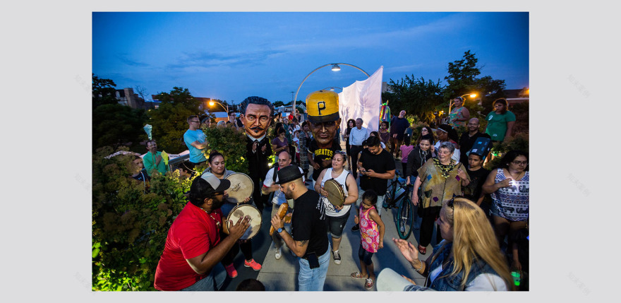
▲节日:夏季的居民节庆。
Festival. A summer neighborhood festival© Trust for Public Land

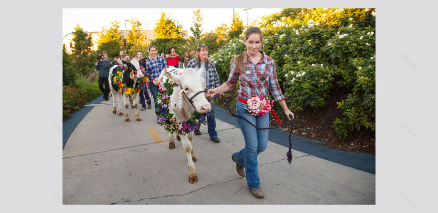
▲游行:城市与乡村的交融。Procession. City and country come together© Trust for Public Land

▲多模式路径:自行车与行人共享道路。Multi-modal Path. Bicycles and pedestrians share the path©Scott Shigley

▲Milwaukee 大街:街道上设置了 13 个新的入口点。Milwaukee Avenue. 13 new access points were made©Scott Shigley

▲鸟瞰:位于芝加哥西北部的 606 公路。Aerial. The 606 in Northwest Chicago©Alex MacLean
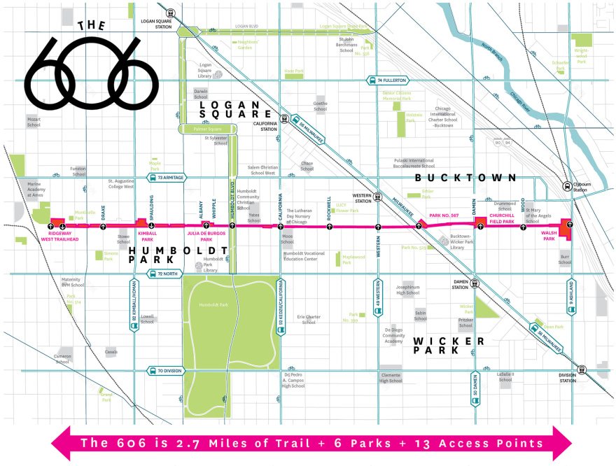
▲场地平面图:606 绿道将 4 个社区聚集在一起,并为超过 2 万名儿童提供了直接进入公园的路径。
Site Plan. The 606 brings 4 neighborhoods together and provides immediate park access for over 20,000 children© MVVA

▲夏日夜晚:一次街区聚会。Summer Evening. A block party© Trust for Public Land

▲近景鸟瞰:入口点和杨树林。Close Aerial. Aerial view of an access point and the poplar grove© Alex MacLean

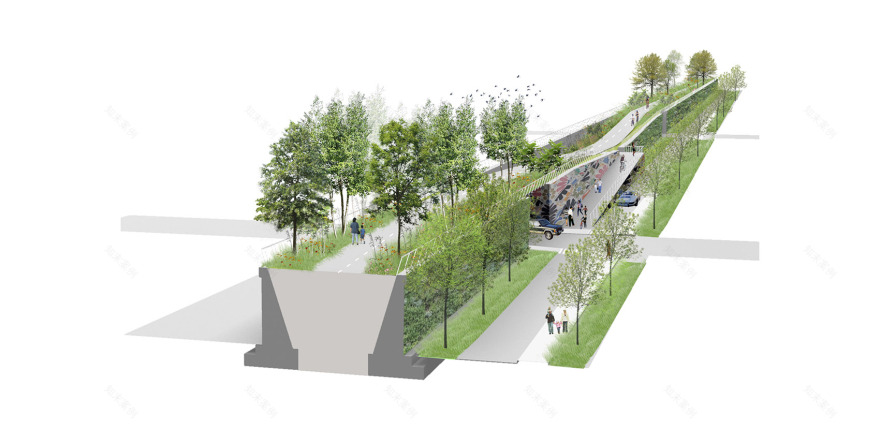
▲剖面透视图:经过修整后,铁路基础设施变得更加方便人们进出。Section Perspective. The existing rail infrastructure is modified to facilitate access© MVVA

▲567 号公园:6 个相邻的社区如今与 606 绿道直接相连。Park No. 567: 6 adjacent neighborhood parks were modified to connect to the 606© Trust for Public Land

▲Instagram 照片:社交平台上的图片反映出 606 绿道的受欢迎程度。Instagram Images: Instagram images show the 606’s popularity © Instagram
PROJECT NARRATIVE
Chicago Roots
The project is firmly rooted in Chicago’s physical history. After the Great Fire of 1872, tracks were laid along Bloomingdale Avenue to help facilitate reconstruction. The Bloomingdale Line was elevated in 1913 to avoid the dangers of street-level rail traffic. The railway company built monumental concrete abutments, 7 feet wide at the base and 16 feet high, to retain the massive amounts of crushed rock and soil on which the tracks would rest. This fill supported the railway along most of its length, while engineered overpasses spanned major streets.
By the mid-1990s, industry had left the increasingly residential area and volunteer flora colonized the underused rail line. The communities along the line created an impromptu path with unparalleled views of the city, but occasional train use continued. In 2001, all freight traffic ended on the line. In 2003, the City’s Department of Planning and Development held public meetings to determine how to bring new open space to the area. The idea of converting the Bloomingdale Line into a park was born.
Two Decades of Advocacy
The nonprofit Friends of the Bloomingdale Trail was founded in 2003 to build on the momentum that had started in the surrounding communities. The group assumed a prominent role in laying out the vision for an integrated trail and park system that would later be renamed “the 606,” reflecting the shared start to the zip codes of the neighborhoods it connects. This grassroots organization built community support and Partnered with The Trust for Public Land to serve as the client, raise funds and manage the project through construction.
Throughout the planning and design process, the Friends group convened multiple meetings between neighborhood constituents and the design team, including a three-day charrette. In response to the range of requests from the community, client, and funders, the landscape architects developed a series of design strategies that integrated connectivity, strategic planting, accessibility, and recycled infrastructure into the repurposing of the historic rail line.
The final design was developed from 2006 to 2014. The park opened to the public in June 2015. By 2018, more than 1 million people, most of them Chicago residents, were using the trail each year.
Connectivity
The 606 offers cyclists and pedestrians the rare opportunity to traverse the city uninterrupted, with connections to major vehicular intersections, bus routes, the CTA Blue Line, and historic Humboldt Boulevard provided via ramps. The access point at Humboldt Avenue, near the midpoint of the trail, links 606 users to a major north/south greenway and to 200-acre Humboldt Park to the south. The project received a substantial TIGER grant from the U.S. Department of Transportation, in recognition of its importance as a transportation corridor.
The elevated structure is mostly 30 feet wide and gets as wide as 60 feet at the western end. To comfortably accommodate bikers and pedestrians traveling in both directions, the landscape architects made the trail itself 14 feet wide. Like passing lanes on highways, higher-speed bicycling lanes are located along the median, with walking paths on the outside edges of the trail adjacent to lush planting.
Strategic Planting
Early meetings with the city demonstrated that neighborhoods surrounding the Bloomingdale Line were starved for public green space. Their desire to turn the Bloomingdale Line into a park led to the strategy of densely planting the edges of the elevated rail line itself while also creating or expanding four “access parks” that reach out into adjacent communities.
Continuity and variety drove the project’s planting strategy. Certain elements are repeated for the full length of the 606. Tall evergreens serve as sentries at every entrance. A layer of grasses and sedges provides year-round texture along the entire trail, as do burr oaks. Artists left their mark on the horticulture. For example, Amelanchier was planted in locations determined by conceptual artist Frances Whitehead to reflect the different microclimates along the trail. Within this overall framework, specific episodes of intensive planting, such as the Poplar Thicket, Urban Savanna, Sumac Tunnel, and Gingko box, create needed variety along the long, narrow site.
At key moments, the landscape architects cut into the structure and lowered the existing grade of the trail. This concept reduced the burden on access ramps and parks and revealed the uniqueness of the existing structure, which, unlike other elevated rail lines, is a solid object rather than a continuous bridge. It also introduced variety into the experience of what would otherwise have been a perfectly flat site.
Accessibility
After falling into disuse, the Bloomingdale Line became a major impediment to circulation. At street level, it was a thick, concrete wall that cut through northwest Chicago. Its elevation and separation from everyday activity made it a magnet for unwelcome uses. Making the 606 inviting rather than imposing was a primary design goal. This was accomplished by providing as many access ramps and stairs as possible, responding to a central piece of input from the community. The high degree of accessibility strengthens the urban impact of the project, which now gives 80,000 residents, including 20,000 children, public green space less than a 10-minute walk from home.
Four of those access points are part of new parks. These “access parks” are essential elements of the 606, creating spacious landscapes impossible on the trail itself. Each of the parks is tailored to the needs of its specific community. Julia de Burgos Park and Playground (.5 acres) and Walsh Park (2.18 acres) already existed as public spaces but were expanded and modified to connect to the 606. Park No. 567 (.33 acres) is a new neighborhood park that was created specifically to provide access and community space on both sides of the trail, including a leisurely winding path on one side and a grand staircase on the other. Churchill Field Park (1.4 acres) adds a sloped, earthen berm to connect an existing park, dog run, and baseball field to the new trail.
Recycled Infrastructure
The landscape architects decided early on to spend as little money as possible rebuilding superfluous structural elements. Instead, decaying sections of the concrete embankments were simply removed. This approach made the park more financially feasible and less repetitive than it might have been, since interventions were based on specific site conditions rather than an overall design vision.
A Recognizable Park
As part of their effort to turn a barricade and nuisance into a welcoming public space, the landscape architects outfitted the access parks with familiar elements: standard Chicago Parks Department lights, benches, trashcans, and fences. Along the trail itself, a more modern aesthetic prevails, with custom lighting and galvanized steel rails. This duality reflects the 606’s hybrid nature as a both a transportation route and a welcoming neighborhood amenity. What was a derelict barrier to circulation is now a lush transit connection and a proven asset to the city.


南京喵熊网络科技有限公司 苏ICP备18050492号-4知末 © 2018—2020 . All photos and trademark graphics are copyrighted by their owners.增值电信业务经营许可证(ICP)苏B2-20201444 苏公网安备 32011302321234号
苏公网安备 32011302321234号客服
消息
收藏
下载
最近