

创作上传
VIP
收藏下载
登录 | 注册有礼
查看完整案例

收藏

下载

分享
项目概述
PROJECT STATEMENT
宁波走廊创造性的综合了当地地势、水文和植被特点,将不适宜居住的棕地变成3.3千米长的“活体过滤器”,增加了生态环境的多样性,协调了人类活动与野生环境的关系,在中国经济快速发展的环境下,成为城市可持续扩张与发展的典范。
Through the innovative synthesis of topography, hydrology and vegetation, the Ningbo Eco-Corridor project transforms an uninhabitable brownfield into a 3.3km long “living filter” designed to restore a rich and diverse ecosystem, create synergy between human activity and wildlife habitat, and serve as valuable teaching tool and model for sustainable urban expansion and development in China’s rapidly advancing economy.

△ Landscape Master Plan. Ningbo Eco-Corridor project transforms an uninhabitable brownfield into a 3.3km-long “living filter” designed to restore a rich and diverse ecosystem, and serve as a valuable teaching tool and model for sustainable urban development. 景观总体规划。宁波生态走廊工程将不适于居住的废弃棕地打造成绵延3.3公里的“活体过滤器”,旨在还原丰富多样的生态系统,并可作为城市可持续发展的教学典范。
背景
宁波位于中国东部沿海、长江三角洲的中心,城市人口为349万(2010年人口普查),是中国最古老、最有名的城市之一,也是对外贸易的主要港口和重要的经济中心。和全国其他城市一样,宁波近年来也面临着迅速增长人口数量给基础设施造成的压力,这也当地政府设下了巨大的挑战:既要调节城市密度,还不能对环境造成消极影响。2002年,为了减轻宁波老城的压力,开创城市扩张的平衡生态新方法,宁波规划部提出建设“宁波东部新区”的计划。该计划包括6平方英里的城市发展多功能用地,环抱在生态走廊四周,共同组成一条绿色线型网络供人类和野生动植物和谐相处、欣欣向荣。
区域生态环境
宁波地处长江平原常绿林生态区的南部,生态区内间歇性河流形成的湖盆,周围发育着大片常绿橡树林和芦苇沼泽。但由于长期的农耕作业和城市发展,湿地和水生生境大面积减少。现存湿地仍然是候鸟和水生生物重要的栖息地,如东方白鹳、天鹅、白枕鹤,水生生物有白鳍豚、扬子鳄、獐子和水獭。设计团队深知湿地和水生生境对这片生态区意义重大,因此尽其所能恢复湿地,针对地域特点进行干预符合新时代的生态意识,具有历史和文化意义。
实地调查
宁波运河系统一直以来承担着防洪、灌溉和运输三项任务。生态走廊区内的运河由于转作工业用途,又缺乏有效分区和对污染的控制,导致运河水质严重恶化。随着工厂大量兴建,施工挖掘出的受污染的土壤被非法任意倾倒,工厂污水未经处理就随着雨水径流排入运河,并滞留在河水里。要想达到预期效果,需要掌握大量数据。因此,主要的景观设计师协同相关顾问(水质学家、湿地专家和水文工程师)展开详细彻底的调查分析,充分了解当地状况、测绘出水文循环图和自然水流分布图、对潜在的协同效应进行预判。
实施——打造“活体过滤器”
通过分析,设计师和相关专家提出了修建微型长江生态区的构想。在地势相对较低的山坡间建造水道网络以改善运河水质,将雨水径流引入新开发区域,修建河岸带为野生生物提供栖息地,为新居民提供兼具休闲娱乐和教育教学功能的场所。
水文:蜿蜒的新水道提升水文功能
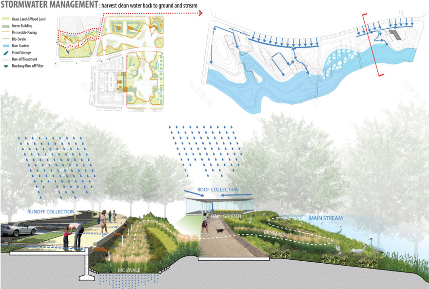
目前缺乏系统规划的无出口运河将不复存在,取而代之的是许多自由流动的小河、小溪还有池塘、沼泽。它们水流蜿蜒而缓慢,几乎还原了低地河漫滩的原始状态,以辅助重建原生生态环境。通过创新的生物修复技术模拟本土生态过程,新建成的水道可以改善运河水质,目前运河中的水属于最差的第V类水,仅适于工业用水和农田灌溉,净化后可达到适宜生态修复和人们休闲娱乐使用的第III类水。
地形:丘陵山谷系统引导水流方向
通过对周边开发区的开挖与填埋,整个生态走廊区就成了地势起伏的山丘和山谷。这些山丘山谷都是精心排布的,顺着山谷形成的水道不仅可以通过沉积、曝气和生物过程去除污染物,还为含水层的补给提供了保障,在其流动过程中,也形成了多种不同的水体形态。
植被:本地植物净化水质,营造生活环境
在地势起伏的景观区,落叶树种和常绿树种的战略布局体现了设计师对美学、规划、生态和气候的综合考虑。大力种植本地植被将帮助走廊重建多样的植被群落,吸引野生动物栖息于此。河岸的植被、生物洼地和雨水花园可以净化来自附近开发区、其他建筑区等硬质景观的雨水。植物选择营造了独特的地域感:随着地势的变化,植被种类呈现组群差异,根据植物的不同高度、形态和颜色呈现出独特的空间格局。
与城市结构融为一体
生态走廊支撑着宁波新城的开放空间系统,将土地划为多种用途,并将它们联系在一起。生态走廊全长3.3千米,与周围城市结构和自然体系完美相合。这条绿色丝带与周围景观交相辉映,相得益彰。
宁波生态走廊通过修复该区生态网络为原生动植物提供了栖息地,改善了公共环境,为当地和附近居民营造出一个乐趣无限的公共空间,表明中外可持续发展已经走上了一个新的台阶。

△ Recognizing that wetland and aquatic habitats hold the greatest conservation significance for this eco-region, the design team focused their energies on a site-specific intervention that would have historical and cultural relevance in the new era of eco-consciousness. 设计团队深知湿地和水生生境对生态区的保护意义重大,因此尽其所能,因地制宜发挥干预作用,在生态意识的新时代里具有重大的历史和文化意义。

△ Within the Eco-Corridor site, the historic canals that characterize the Ningbo region had become severely degraded with the introduction of industrial uses in the absence of effective zoning and pollution controls. 生态走廊区内,运河曾经是宁波的标志,用作工业用途后,由于缺乏整体分区规划和污染控制,导致运河水质严重恶化。

△ Hydrology filter layer: Replacing the existing system of dead-end and disconnected canals is a series of free-flowing rivulets, streams, ponds and marshland that will support the re-establishment of the indigenous ecology. 水文过滤层:目前缺乏系统规划的无出口运河将不复存在,取而代之的是许多自由流动的小河、小溪还有池塘、沼泽,帮助重建原生生态环境。

△ Topography filter layers: Incorporating construction fill from the surrounding development areas, the corridor is carefully graded to create hills and valleys that direct the flow of water across the site. Vegetation filter layers: Native vegetation supports plant diversity and encourages colonization by indigenous wildlife. Variegated plantings also serve to purify groundwater, cleanse stormwater run-off and create a unique sense of place. 地形过滤层:通过合理的开挖与填埋,整个生态走廊区会形成严格分级的山丘山谷区,引导水流途径。 植被过滤层:本地植被有利于植物多样化,吸引当地野生动物栖息于此。丰富多样的植物也承担着净化地下水和雨水径流的职责,营造独特的地域感。

△ The Eco-Corridor zone is carefully graded into contours creating a terrain of hills and valleys. Valley waterways serve to remove pollutants through settlement, aeration and bio-processing, while the hills provide vista points for visitors and increase habitat diversity. 生态走廊区经过精心分级,形成山丘山谷地形。山谷形成的水道通过沉积、曝气和生物作用去除污染物,山丘为游客提供观景场地,也增加了生活环境多样性。

△ The Eco-Corridor zone is carefully graded into contours creating a terrain of hills and valleys. Valley waterways serve to remove pollutants through settlement, aeration and bio-processing, while the hills provide vista points for visitors and increase habitat diversity. 生态走廊区经过精心分级,形成山丘山谷地形。山谷形成的水道通过沉积、曝气和生物作用去除污染物,山丘为游客提供观景场地,也增加了生活环境多样性。

△ Water sampling and mapping of the local hydrological cycle and natural flow of water across the site inform strategies for water quality improvement from Class V, restricted use to Class III, suitable for recreational activities. 通过水样采集和绘制当地水文循环图和自然水流分布图,制定出水质改善策略,从仅限工农业使用的第V类水改善成适宜文娱活动的第III类水。

△ In collaboration with water-quality scientists, a system is designed using passive and active methods to aerate and encourage water movement over plant roots to remove contaminants. 通过与水质学家合作,设计师通过使用主动和被动充气方法,促进地下水流穿过植物根系去除污染物。

△ In collaboration with wetland experts, a site-specific system of free water surface, floating, and riparian wetland are designed to remove targeted pollutants. 通过与湿地专家合作,由自由水体表层、流动和河岸湿地构成的特定地域系统可以对目标污染物起到移除作用。

△ Stormwater run-off is collected and treated before entering the major waterway. This process is demonstrated and included in the park program and design for educational purposes. 雨水径流经过集中收集、处理后排入主水道。整个过程已经得到验证并纳入园区计划中,还可用于以后的教育教学。
△ Stormwater run-off is collected and treated before entering the major waterway. This process is demonstrated and included in the park program and design for educational purposes. 雨水径流经过集中收集、处理后排入主水道。整个过程已经得到验证并纳入园区计划中,还可用于以后的教育教学。

△ The Riparian Buffer zone replaces existing impervious, vertical canal banks with soft, sloping vegetated banks. The riparian planting edge provides a green buffer and aquatic habitat, and aids the removal of contaminants from canal water and stormwater runoff. 河岸缓冲带取代了运河防水抗渗的垂直河岸,缓冲带土壤松软,坡度偏缓,覆盖着植被。河岸植被边缘的绿色缓冲区形成水生环境,并有助于从运河水和雨水径流中去除污染物。

△ Wildlife Habitat structures like habitat logs and perch trees are planned along the riparian edge to jump-start habitat complexity and species richness function. 野生动物栖息地结构诸如原木栖息地和树木栖息地将沿着河岸边缘发育,构成复杂的栖息地,维持丰富的生物种类。

△ The design team identified emergent sustainable opportunities like waste concrete and excessive soil from surrounding urban development to create landscape topography to direct water, buffer the urban environment, provide vista points, and increase habitat diversity. 设计团队还采取了可持续性建设,比如利用废弃的混凝土和周边城市发展产生的过量土壤建成起伏的景观地形引导水流途径,缓解城市环境,提供观景点以及增加生活环境多样性。

△ Ningbo Eco-Corridor creates a vital habitat for native flora and fauna, enhances public health, creates fun and enjoyable public spaces for local and neighboring communities, and raises the bar for sustainable development in China and beyond. 宁波生态走廊是本地动植物的重要栖息地,不仅改善了公共卫生、还为当地和附近居民提供了一个乐趣无穷的公共空间。
PROJECT NARRATIVE
Background
Situated on China’s eastern coastline in the heart of the Yangtze River Delta, with an urban population of 3.49 million (2010 Census), the city of Ningbo is one of China’s oldest and best-known cities, a key port for foreign trade, and an important economic center. As with many other cities across the country, phenomenal population growth in recent years has put an enormous strain on infrastructure, posing a monumental challenge for the local government to accommodate urban densification while minimizing negative environmental impacts.
In 2002, with the intention of alleviating pressure on the Old City while setting a precedent for a balanced, ecological approach to urban expansion, the Ningbo Planning department called for a master plan for the creation of the “Ningbo Eastern New City.” The plan would include 6 square miles of mixed-use urban development organized around a signature “Eco-Corridor,” comprised of a linear network of green spaces in which humans, wildlife and plants could inhabit, co-exist, and thrive.
Eco-Regional Context
Ningbo is situated in the southern part of Changjiang Plain Evergreen Forest Eco-Region within the low-lying Changjiang (Yangtze) River delta.
This eco-region was historically characterized by extensive evergreen oak forests and reed swamps surrounding seasonally-inundated lake basins. Centuries of agriculture and recent urban development have resulted in a significant loss of wetland and aquatic habitat. The few wetlands that remain provide vital habitat for migratory birds such as oriental white storks, swan geese, and Siberian and white-naped cranes, and aquatic animals such as Yangtze River dolphins, Yangtze alligators, Chinese water deer, and otters.
Recognizing that wetland and aquatic habitats hold the greatest conservation significance for this eco-region, the design team focused its energies on wetland restoration as the impetus for a site-specific intervention that would have historical and cultural relevance in this new era of eco-consciousness.
Site Investigation
The Ningbo region is characterized by a canal system that historically performed a set of functions including flood control, irrigation and transportation. Within the Eco-Corridor site, the canals had become severely degraded with the introduction of industrial uses in the absence of effective zoning and pollution controls. As successive generations of factories were built, contaminated soil from construction excavation was dumped illegally and randomly through out the area, with factory sewage and stormwater runoff allowed to flow untreated into the canals rendered stagnant by ad-hoc infill.
Knowing that an effective and meaningful intervention would require sufficient data about the underlying conditions of the site, a thorough analysis was conducted by the leading landscape architects and affiliated consultants–including water-quality scientists, wetland experts, and hydrologic engineers–in order to fully understand the existing conditions, map the local hydrological cycle and natural flow of water across the site, and identify potential synergies.
Implementation – Building a Living Filter
Out of this analysis emerged the concept of creating a microcosm of the Changjiang eco-region. A networked series of waterways organized by low, undulating hills was designed to treat polluted water from the established canal system, manage stormwater runoff from the newly developed areas, establish riparian zones for the restoration of wildlife habitat, and provide recreational and educational opportunities for the new inhabitants.
Hydrology: a new meandering watercourse to improve hydrological function
Replacing the existing system of dead-end and disconnected canals is a series of free-flowing rivulets, streams, ponds and marshland. The hydrological flow is designed to be slow and meandering, approximating the original conditions of the lowland floodplain, in order to support the re-establishment of the native ecology.
Through innovative bio-remediation technologies that mimic indigenous ecological processes, the newly constructed watercourse improves the existing quality of the canal water from Class V, restricted to industrial and agricultural uses and not fit for human habitation, to Class III, which is suitable for ecological restoration and recreational use.
Topography: a system of hills and valleys directs water flow
Incorporating fill from excavation in the surrounding development areas, the entire Eco-Corridor zone is carefully graded and shaped into contours creating a terrain of hills and valleys. The valley waterways serve to remove pollutants through settlement, aeration and bio-processing, allow retention for aquifer recharge, and highlight the different modalities of water as it moves across the site. The hills also serve to buffer the urban environment, frame views to the New City, provide vista points for visitors, and increase habitat diversity.
Vegetation: native plantings cleanse water and create habitat
Across this undulating landscape, the strategic placement of deciduous and evergreen species reflects aesthetic, programmatic, ecological, and climatic considerations. An emphasis on native vegetation supports the re-establishment of diverse plant communities along the length of the corridor, and encourages colonization by indigenous wildlife. Plantings along the riparian edge, and bio-swales and rain gardens throughout the site, cleanse stormwater run-off from the adjacent development and other building and hardscape areas. Plant selection also creates a unique sense of place: together with topographical variety, differentiation of species into groupings based on height, texture and color creates distinct spatial patterns.
Integration With the Urban Fabric
The Eco-Corridor serves as the spine of Ningbo New City’s open space system, creating and connecting a variety of land uses. Extending 3.3 km, the Corridor merges seamlessly with the adjacent urban fabric and natural systems, creating a symbiotic relationship between the greenway and surrounding landscape.
By restoring the ecological network in this region, the Ningbo Eco-Corridor creates vital habitat for native flora and fauna, enhances public health, creates fun and enjoyable public spaces for local and neighboring communities, and raises the bar for sustainable development in China and beyond.
南京喵熊网络科技有限公司 苏ICP备18050492号-4知末 © 2018—2020 . All photos and trademark graphics are copyrighted by their owners.增值电信业务经营许可证(ICP)苏B2-20201444 苏公网安备 32011302321234号
苏公网安备 32011302321234号客服
消息
收藏
下载
最近