

创作上传
VIP
收藏下载
登录 | 注册有礼
查看完整案例

收藏

下载

分享
翻译
Faculty of fine arts
Architecture department
Second Year of Architecture - Academic Surveying Of Architecture ProjectGRADE: A+
Date : 2023-2024
used software: Autodesk Revit - Autocad -sketch up - Lumion - Enscape - Photoshop
Polycam - 3D civil - Excel - Measure

Surveying, as a specialized field within the realm of surveying science, is dedicated to the meticulous determination of the relative elevations of points dispersed across the Earth's surface. This discipline assumes a pivotal role in the precise measurement of both angular and linear dimensions. The paramount significance of surveying is underscored by its unparalleled capacity to intricately ascertain variations in height among diverse locations and specific points of interest.

AL-HAKIM MOSQUE
Location: Islamic Cairo, on the east side of al-Mu'izz Street, just south of Bab al-Futuh The mosque's rectangular layout with dimensions of 120m * 113m includes a courtyard measuring 64m * 77m (constructed in 78 AH / 66 AD). It is surrounded by arcades (riwaqs) on four sides, consisting of five corridors intersected by a passageway


Surveying of the Faculty of Fine Arts in Zamalek, Helwan University

Vilaa Abood (15.5 m height) Consists of: Ground floor: (3.25m height) First floor:(4.5m height) Second floor: (4.5m height) Third floor: (3.25m height)


Administration building (15m height) Consists of:
Ground floor (4.45 height) Student affairs sector
First floor(4.45 height): administration student affairs and college clinic
Second floor(4.25 height)

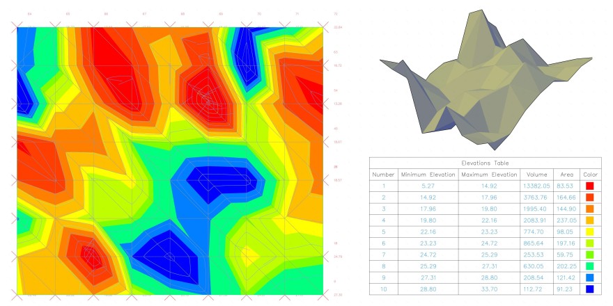
A contour survey is crucial for understanding the topography of a piece of land. By mapping the contours, it helps identify slopes, elevation changes, and existing features, providing essential information for various purposes like construction, landscaping, or environmental assessments
南京喵熊网络科技有限公司 苏ICP备18050492号-4知末 © 2018—2020 . All photos and trademark graphics are copyrighted by their owners.增值电信业务经营许可证(ICP)苏B2-20201444 苏公网安备 32011302321234号
苏公网安备 32011302321234号客服
消息
收藏
下载
最近