

创作上传
VIP
收藏下载
登录 | 注册有礼
查看完整案例

收藏

下载

分享
Urban Landscape – Los Angeles: The Contemporary City
By Khushro Ansari
- May 11, 2022
885

Urban Landscape - Los Angeles
Urban Landscape – Los Angeles is located in the Western United States in South California. However, the city is nearly 470 square miles in land area and has an irregular shape with the expensive areas in the northern portion of the city. With its 4,000,000 population, it is the second most crowded city in the U.S. after New York. The city is known for its Mediterranean climate and its sprawling metropolis. Also, being one of the leading centers in terms of business international trade and commerce, entertainment, industry, culture, fashion, media, and technology makes the Los Angeles region the third wealthiest region in the world.

Urban Landscape – Los Angeles: The Contemporary City
History of The Contemporary City as Urban Landscape- Los Angeles
Los Angeles City has a rich history back to the time long before California became the territory of the United States. However, it was officially founded on September, 4, 1781 by Spanish governor Felipe De Neve named El Pueblo de Nuestra Señora la Reina de Los Angeles( the village of our lady and the Queen of Angels). Pueblo became a Mexican city in 1821 after the Mexican War of Independence. Thus, throughout the 1850’s municipal officials used the maps of Pueblo to sell off some city’s land. However, after subsequent years new surveys and plans were replaced by the old plans for the growth and development of the city. Thus, Pueblo officially became the City of Los Angeles under the U.S system in 1850.
Los Angeles in 1781 when known as “The Pueblo”
Los Angeles in 1871
The period between 1913 - 1941 served the development and planning in Los Angeles as the city was facing a rapid increase in population, business expansion and traffic congestion. Therefore, it was needed to expand and divide the city into two main districts: residential, and industrial ( zoning). With this, a city planning committee established under Gordan Whitall( the Planning Director) as he commissioned 5 people to control the major planning areas such as:
- Official plans
- Zoning
- Building lines
- Subdivisions
- Public Building and Recreational Areas.

Old survey map of Los Angeles 1849

Downtown Los Angeles Aerial View 1935
Master Plan-
After World War II In 1946, a new comprehensive Zoning Ordinance became effective. So that was built with the hard work of many years that resolved the prior zoning issues. The plan was a comprehensive plan for the central city and included aspects such as: To meet present-day conditions of Los Angeles and adequately zone all areas. Also, to make sure none of the past zoning mistakes were repeated. To ensure the elimination of nonconforming buildings in residential areas by creating more demands for off-street parking and enactment of density- control.
Moreover, the plan started to come together in 1964 after the sprawl and suburbanization occurred in Downtown Los Angeles in San Fernando Valley. The document concluded the basic transportation needs for the downtown area for example:- Completion of freeways. Computer-controlled traffic-controls. Diversion of all through traffic. A stronger method to service buildings.
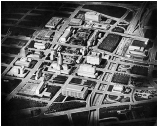
The Civic Center plan

Master plan goals
In 1970, the Department of City Planning commissioned its Concepts of Los Angeles General Plan for reorganizing Los Angeles’ city form which served as the city’s framework for the future general plan. The plan was also designed to meet the city’s needs based on a projected population of 5 million within the city and 11 million for the metropolitan area. However, the document highlighted critical urban problems like air pollution, traffic congestion, inadequate public transit, and limited airport capacity. The main five elements of the Concept of Los Angeles were:
- The Centre’s concept emphasizes both single-family and high-density housing. However, a total of 48 centers were identified, of which 29 are located within the City’s boundaries. Each center would vary in size but all would have a “core” that would be near transit stations to promote transit transportation.
- The dispersed concept is based on the single dwelling concept and the low - medium-density housing.
- Open spaces - the planning also includes various sizes (small parks, plazas, community parks in suburbs, and extensive rail network).
- Industrial areas scattered throughout the city are compatible with other adjacent land - use.

Concept plan Los Angeles(1970)
Rapid Transit Station located in the “Centre”
However, this plan was not initially successful but adopted as a part of the General Plan in 1974 as it was able to identify the city’s main planning issues.
The General Plan 1974 – Urban Landscape- Los Angeles
To provide stability for single-family residential neighborhoods from encroachment by other types of uses.
To provide a maximum advantage for the high and medium-density housing.
Introducing more employment opportunities and commercial services at locations that are convenient to residents.
Providing adequate transportation facilities for people and goods.
To conserve the city’s natural resources and amenities.
To enhance the quality of the city’s physical environment and development with the urban design principles.

Los Angeles regions
Los Angeles County consists of a collection of 7 main regions which are as follows: - Antelope Valley, Central L.A., Gateway Cities, San Fernando Valley, San Gabriel Valley, Santa Clarita Valley, South Bay, and Westside.
Famous Los Angeles Freeways
Traffic congestion was a great concern by the late 1930s in the Los Angeles metropolitan area and it still continues with an increase in population every year. At that time Automobile Club of Southern California designed a detailed plan to create an elevated freeway - type “Motorway System,” which meant the dismantling of the streetcar lines, to be replaced with buses that could run on both local streets and new express roads.
The city of Los Angeles has an upgraded rail transit system focused on its central city. However, the success of the Arroyo Seco Parkway built between Los Angeles and Pasadena in 1940, convinced many that a freeway system could solve the region’s transportation problems.

L.A Airports and Freeways Plan
Los Angeles Freeways
Los Angeles Freeways
Conclusion
Due to the expansion in population, traffic congestion and pollution are the major concerns of the city. However, L.A. has, at present, few parks and fewer plazas. Moreover, in their place are wide streets and huge parking lots with buildings scattered in-between. The city needs to change, therefore the City’s Planning Department has come up with the vision to “Deemphasize the Cars” with its “Mobility Plan 2035”. However, the Mobility Plan includes policies that identify an enhanced complete street system with the balance of various transportation systems which includes things like bike lanes, traffic calming, and pedestrian infrastructure that will change the urban structure of the future city and make it relatable for its residents.
Khushro Ansari
Khushro Ansari is an Architect. While juggling between college submissions and research deadlines he finds time to write about architecture and founded archEstudy. He is a passionate individual with a penchant for architectural design, innovative design, and creative writing. He aspires to bring design activism and sustainability to the forefront in all his professional endeavors.
南京喵熊网络科技有限公司 苏ICP备18050492号-4知末 © 2018—2020 . All photos and trademark graphics are copyrighted by their owners.增值电信业务经营许可证(ICP)苏B2-20201444 苏公网安备 32011302321234号
苏公网安备 32011302321234号客服
消息
收藏
下载
最近