

创作上传
VIP
收藏下载
登录 | 注册有礼
查看完整案例

收藏

下载

分享

‘Floodprints’ Are Helping Rural Communities Recover From Disaster
In North Carolina, landscape architects at Coastal Dynamics Design Lab work with small towns on flood mitigation.

Hurricane Florence flooded about half of all buildings in Pollocksville. In 1993, Pollocksville, North Carolina, Mayor Jay Bender, who’s run the small town for more than 40 years, worked “like crazy” to convince the U.S. Army Corps of Engineers to allow him to build on the Trent River. The river runs through Pollocksville, and at the turn of the 19th century, ferries and barges plied its busy waters. Now the town’s waterfront was overgrown and in disrepair, and Bender wanted to reopen river access. The corps, however, refused him permission to build there because it was a wetland.
Not easily deterred, Bender contracted a group of prison inmates to cut back the vegetation until the riverside looked “like a golf course.” It was summer, hot, and it hadn’t rained in weeks. Bender called the corps and told them to come, quickly, and reinspect. “See?” he told them. It was bone-dry. They gave him the go-ahead. The city placed a historic train depot to serve as town hall on the spot, paved a parking lot, built a boat ramp, and called it Pollocksville Waterfront Park.
Then came Hurricane Floyd in 1999, Matthew in 2016, and Florence in 2018. Each brought floods and destruction.
On a recent blustery afternoon, Bender visited the Waterfront Park, which was recently turned back into a constructed wetland, with a boardwalk and seating. Tufts of golden switchgrass and little bluestem glowed in the high noon sun and rustled in the sharp wind. He called it, cheekily, the “weed garden.”
The wetland was built as part of a larger resilience plan put together by the Coastal Dynamics Design Lab (CDDL), a nonprofit staffed by landscape architects who work with small North Carolina towns on hazard reduction. The plan outlines both economic development and flood mitigation projects and has helped Pollocksville secure more than $4 million in grant funding to implement them. The ongoing work, and available dollars, are novel for a community with a population of around 300 people, and CDDL is re-creating Pollocksville’s success in other parts of rural North Carolina.
“I think the typical way of thinking is let’s work out resiliency in big cities, or big regions. That does not trickle down to small places because it doesn’t deal with the capacity gap,” CDDL Director Andrew Fox, FASLA, says. “But if you can figure it out in a place that has very little, it scales up really easily.”
The mayor still struggles with the “weed garden,” on which he signed off. But it’s growing on him. “We’re kind of the envy of other towns,” he says with a grin.
The Coastal Dynamics Design Lab was founded in 2013 by David Hill and Fox at North Carolina State University. They wanted to bring students in the architecture and landscape architecture programs into communities experiencing flooding and climate change–driven hazards, to get them thinking about how design, with its “elastic and agile” approach to problems, could contribute to recovery, adaptation, and mitigation work. They ran studios for their classes focusing, initially, on the coast, which in North Carolina has seen increased flooding over the past several decades. But when Hurricane Matthew hit in 2016, the most affected communities were those in the coastal plain, on shallow rivers prone to significant flash flooding. Hill and Fox started taking students more inland.
Then another, even more destructive storm, Florence, hit in 2018. Together, Matthew and Florence caused $22 billion in damage in North Carolina, from which communities have yet to fully recuperate. Many of the affected municipalities are small, with volunteer governments and no funds to drive recovery.
The Coastal Dynamics Design Lab (CDDL) helps small, rural communities recover from natural disasters. For each one, they’ve put together a floodprint to guide rebuilding efforts.
Photo by Madeline Gray.
CDDL pivoted again. Rather than use the lab as a teaching tool for students, Fox turned it into an organization providing technical assistance to towns that may otherwise struggle to move forward. CDDL staff members still run a studio each spring and teach, but the six landscape architects now spend their days fully immersed in resilience planning for places like Pollocksville. They work at the neighborhood scale, filling the gap between major infrastructure projects and individual effort, and prioritize nature-based solutions. Aside from Fox’s salary, CDDL’s budget comes from philanthropy and grants, and they offer their services at no cost to the towns.
At the center of their process is something they call a floodprint, a planning document meant to guide recovery. CDDL spends a year to a year and a half writing it; many of the places they work have experienced repeat traumas, so getting to know the community and building trust are key.
“In an environment that can be either nonresponsive or technical, folks come in and dictate what things are; we are slower, we kind of let it marinate a little bit,” Fox says.
Eventually, they distill what they learn and their own deep analysis into six to eight implementable proposals and invite citizens to vote on their favorites. They refine the top two to four into the final floodprint and start applying for grants.
Their promise to the places where they work is not just a plan, but assistance securing the money to realize it, too. To that end, the floodprint is written specifically to facilitate grant applications. Theoretically, even untrained administrators can copy and paste data and appropriate language into applications. Practically, grants can take years of active and technical correspondence before a dollar arrives, so CDDL usually shepherds grant applications through the complicated processes in - house.
When the money starts coming in, CDDL takes on the role of an owner’s representative, helping to write RFQs and to choose design firms and contractors to take over from the lab’s renderings. They provide active management and continuity from vision to project completion, making sure the intent of the floodprint is upheld.
CDDL has produced or is currently producing floodprints for 10 communities and has successfully guided them to nearly $13 million. (Another $20 million is in pending applications.) They continue studying potential new grants and fine - tuning their process into an increasingly turnkey, replicable one. Pollocksville has served as a proving ground.
Pollocksville is a tiny agricultural town that used to produce tobacco but now grows mostly corn and soybeans. Town Commissioner Nancy Barbee remembers it as a bustling place when she was growing up, with a Main Street full of businesses.
“You didn’t have to go anywhere; we could get everything right there,” she says.
Many people living there were generationally entrenched, with strong connections to the place. “Some of the same families lived here forever,” Bender says.
But by the 1990s, when Bender was eyeing the dilapidated waterfront, Barbee says young people were taking jobs elsewhere and businesses were shuttering. A bypass on nearby Highway 17 was proposed—and eventually built—further isolating the community. Town leaders started thinking about how to reinvent the sleepy enclave, with a focus on the river.
“The Trent River is our greatest asset,” Bender says. “It’s beautiful.”
The Trent meanders north until it meets the Neuse River, which flows out into the Pamlico Sound on the coast. Around Pollocksville, it’s wide, inky dark, and usually calm. Locals have long fished it, and the nearby forests attracted hunters. The mayor and commissioners imagined remarketing Pollocksville as “the gateway to nature.”

The Trent River is Pollocksville’s greatest asset and liability. Photo by Madeline Gray.

A high-water mark from Hurricane Floyd that was surpassed in 2018. Photo by Madeline Gray.
“We had the vision of creating an area where people would come for walking, riding their bikes, hunting, fishing, all kinds of sports, baseball,” Barbee says.
Floyd, in 1999, and Matthew, in 2016, showed the river’s other, tumultuous side. But when Florence hit in 2018, Pollocksville had a real reckoning. The storm surge rose nearly 21 feet, submerging all of the town hall but its roof. The mayor’s first glimpse of the building post-storm was from a boat, on the street. Florence flooded some 75 structures, about half the total buildings, including every single town commissioner’s residence. The town wasn’t in a flood zone, according to official maps, so no one had flood insurance. In addition to Pollocksville’s greatest asset, Bender started thinking of the river as its greatest liability, too.
He and the commissioners realized that the plan they’d started devising to remake Pollocksville would have to be reconsidered in scope. “Because all of a sudden, the plan wasn’t to reimagine, but it was to rebuild and reimagine,” Bender says. “And reimagine in a resilient manner.”
Consultants offered to write a new plan but quoted them a fee of $20,000. Bender says for a town with an annual budget of less than $600,000, including water and sewer operation, that was impossible. And that wouldn’t cover actually fulfilling any of the projects. Then a woman who grew up in Pollocksville and had a connection to the university approached CDDL and told them her hometown needed help. Could they take a look?
CDDL arrived in Pollocksville in 2019. Today, Pollocksville’s population is poorer and older than the North Carolina average. There’s just one operational business on Main Street, a restaurant with limited hours. But most of the families that had flooded had chosen to stay, and the town’s leadership was eager to rebuild better.
“The attitude was almost, ‘We’ll try anything,’” Bender says.
CDDL studied the previous plans, to understand what the residents wanted, and assembled geospatial data to see if their desires conflicted with vulnerabilities in town. They sought input through mail surveys and public meetings, putting in the time to hear people’s concerns. “That was the main thing,” Barbee says. “They listened. And they took what we wanted and made it feasible and made it make sense.”

Andrew Fox, FASLA, and Travis Klondike, ASLA, from CDDL at the new wetland installation in Pollocksville. Photo by Irina Zhorov.
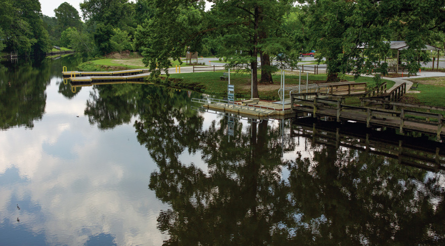
Pollocksville, North Carolina’s completed Waterfront Park will help protect the town from the now-frequent floods.
Photo by Madeline Gray.
CDDL mocked up two plans with eight different land-use proposals. They incorporated ideas from the town’s previous plan but introduced resilience. If a project could be tweaked to better meet a specific grant’s requirements, they suggested that, too.
“Knowing that the end game is typically to attract external resources to fund the projects, we baked that in early in the process,” says Travis Klondike, ASLA, the associate director of CDDL. “Everything from the beginning is with that in mind.”
On the day residents were to vote on their favorite proposals, in February 2021, Waterfront Park, where they had planned to meet, flooded. “I remember that being ironic, because we had just finished modeling work that said that this park will flood on an annual basis,” Klondike says. They postponed for a week. When they finally gathered, more than 60 people showed, about a fifth of the total population. Each person received a bag with four pushpins, and they placed them on the projects they most wanted to see materialize.
“I remember driving home after that feeling so elated, just feeling like we’ve arrived at a point that was at consensus and having that be an important moment,” Klondike says.
The final floodprint sketched out green space, including an event lawn, on lots eligible for a voluntary buyout program; the remaking of Main Street with bike lanes, sidewalks, and bioretention ponds, to absorb nuisance flooding; elevation and floodproofing of commercial properties; and the conversion of the riverside lot where the town hall had stood into wetland. (After Florence, Pollocksville had used
Federal Emergency Management Agency [FEMA]
and state dollars to move the historic building farther away from the river and remodeled it, leaving an empty scar on the land.)
Before the plan had been officially adopted, CDDL applied for a state grant to build the wetland. Klondike happened to be in town the day the mayor got the call that Pollocksville had been selected to receive the money. “He came up so proud,” Klondike says. “He was peacocking at the park, and he had the biggest grin on his face.” The “weed garden,” as Bender now calls it, won’t stop flooding from another 1,000-year storm like Florence, but it will help with smaller storm events that the waterfront is predicted to see annually.
Since the plan’s adoption in the summer of 2021, Pollocksville has also redone Main Street, has been selected for a federal FEMA Building Resilient Infrastructure and Communities (BRIC) grant to elevate business district properties, and is waiting to see which property owners choose buyouts before initiating planning on the event lawn and green space. Aside from unrelated grants to build and fix sewer and water infrastructure, the $4.4 million for these projects has been the biggest influx of money the city has ever seen, and the most updating it has done, too. In parallel, private individuals are also elevating and fixing up properties, both efforts bolstering one another.
CDDL continues to actively manage Pollocksville’s progress. On the day I visited, Klondike conducted a walk-through with the construction crew before they wrapped the Main Street work. The BRIC federal money is still en route, so he’s also communicating with FEMA. The buyouts could take some time, too. Pollocksville is depending on CDDL to see everything through.
“We would just die if CDDL left,” Barbee says.
CDDL is still involved in some capacity in every community where they’ve produced a floodprint, and they’ve started planning in four new communities, too. Their presence provides reliable technical expertise and continuity through what is often a fractured process. But there are limits to what it can take on.
“At some point, for really building capacity, we need to be able to step away from the communities,” Fox says. “Truly building capacity is not building projects but building human capital.” Stepping away has been harder to figure out.

A view toward Pollocksville’s vulnerable businesses. Photo by Madeline Gray.

The town hall was moved from Waterfront Park after Hurricane Florence. In its place was installed a wetland that the mayor cheekily calls the “weed garden.” Photo by Travis Klondike, ASLA.
They’re training students, who may go on to replicate at least some version of the CDDL’s work. (All the employees at the lab, except Fox, are graduates of the North Carolina State University landscape architecture program.) Fox says they’re also constantly fielding inquiries from practitioners interested in their approach: How can we do this where we work? They’ve made strides to answer that question by developing a rural resilience framework to share what they’ve learned.
“We really feel like landscape architects can deal with the complexity that climate-based work requires,” Fox says, “and we don’t want to own this information or the discoveries that we make in terms of this kind of hazard-related work.”
Meanwhile, they’re plugging away in Pollocksville.
At the “weed garden,” Klondike inspected how well the plants were settling in as the mayor shielded his eyes from the sun.
“Are you going to apply for some more money?” Bender asked. It seemed like innocent banter, a conversation starter. But Klondike answered seriously. “I think I might.”
南京喵熊网络科技有限公司 苏ICP备18050492号-4知末 © 2018—2020 . All photos and trademark graphics are copyrighted by their owners.增值电信业务经营许可证(ICP)苏B2-20201444 苏公网安备 32011302321234号
苏公网安备 32011302321234号客服
消息
收藏
下载
最近