

创作上传
VIP
收藏下载
登录 | 注册有礼
查看完整案例

收藏

下载

分享
About Time: Adaptive Management for Coastal Salt Marshes | EMLab + The Wetlands Institute
项目陈述
Project Statement
在全球气候变化的背景下,为地方尺度、景观尺度的变化进行设计,是当今景观建筑师面临的一项重大挑战。这一任务要求将地球系统科学工具——如卫星数据与海平面上升预测——与现场测绘技术相结合。尽管测绘历来是景观实践的一部分,但当下的行业更多依赖外包或标准化数据产品,而这些产品受制于其采集设备与机构背景,存在明显局限。通过构建定制化的现场遥感数据,设计者不仅能够重新将测绘确立为核心专业能力,还能推动新的研究方向,并参与到大尺度、跨学科的沿海基础设施项目中。基于自然的海岸防护策略,正逐渐成为这一研究领域中的关键前沿。
Designing for local landscape-scale change amid global climate change is a significant challenge for landscape architects. It requires integrating Earth system science tools, such as satellite data and sea level rise projections, with on-site surveying techniques. While surveying has historically been part of landscape practice, the discipline often outsources this work or relies on limited off-the-shelf data products. By creating custom in situ remotely sensed data, designers can recover surveying as a central aspect of practice, contribute to new research frontiers, and participate in large-scale, interdisciplinary coastal infrastructure projects. Nature-based coastal mitigation strategies are emerging as one such crucial research ground.

▲在一项由联邦资助的多年期研究项目中,团队正与美国陆军工程兵团及新泽西州环境部门合作,对六处湿地修复工程开展系统建模与持续监测。Our team is modeling and monitoring 6 wetland restorations in a federally funded multi-year project with the US Army Corps and NJ Dept of Environment. © EMLab
项目说明
PROJECT NARRATIVE
景观学者J.B. Jackson曾将景观形容为“时间的艺术”,而“变化”正是这一表述中内在的前提。今天,景观建筑师所面对的核心挑战,是在全球气候变化的大背景下,回应地方与景观尺度上的持续变化。这要求新的制图与建模方法,将地球系统科学中的工具与知识——例如卫星数据与海平面上升预测——与现场测绘技术有机结合。尽管测绘历来是景观实践的一部分,但当下的行业更多依赖外包或标准化数据产品,而这些产品受制于其采集设备与机构背景,难以应对复杂问题,尤其是在快速变化的滨海环境中。
本研究团队与联邦及州级机构合作,对新泽西州沿海共计500英亩的六处湿地修复场地开展建模与长期监测,旨在建立高精度模型,用于指导沉积物投放,并持续追踪盐沼地表高程与植被组成的演变。此类“基于自然的防护要素”正日益被用于应对湿地退化所引发的风暴防御能力下降、生物多样性流失以及碳储量减少等问题。然而,这些具有实验性却至关重要的策略,要求对不同空间与时间尺度上的环境动态有深入理解。由于水位频繁波动以及材料光谱特征的高度不确定性,滨海湿地一直是卫星遥感制图中最具挑战性的地貌类型之一;而现有的州级与联邦土地覆盖数据库,往往以简化分类取代对湿地复杂性的真实呈现。与此同时,受限于地形与通达条件,传统测绘设备在湿地环境中也难以使用。
借助GPS无人机、现场测量接收设备与机器学习算法,团队探索并建立了一套新的景观变化建模与测量方法。通过现场采集的数据,研究人员构建了定制化的光谱数据库,并据此生成“中尺度”的土地覆盖图。这类定制的现场遥感数据在分辨率(信息细致程度)、覆盖范围以及获取频率上均显著提升,更准确地捕捉了模型所需的关键景观特征。这些数据与模型对于确定沉积材料的投放方式与断面形态至关重要,是保障盐沼长期存续的基础。此外,来自历史沉积投放区域的高程测量数据,为确定最有利于高盐沼形成的目标高程提供了依据,同时也优化了低盐沼区域的植被恢复效率。高盐沼在洪水期间为关键鸟类物种提供重要的筑巢空间与临时避难所。
研究团队将对各修复场地开展年度监测,以评估实际表现与模型情景之间的差异。相关成果将为大尺度湿地修复中的沉积物投放技术提供可参考的范式,并可推广至美国大西洋沿岸的其他地区。通过定制化的现场遥感数据,设计者得以重新确立测绘在专业实践中的核心地位,拓展研究边界,并参与跨学科、跨尺度的沿海基础设施建设。J.B. Jackson早已认识到景观始终处于变化之中,但当下的时间尺度已不再是他所设想的那个世界。景观建筑,正是少数能够在历史时间、人类经验时间与全球变暖所带来的“行星时间”之间,探索调和路径的学科之一。

▲现有的大多数土地覆盖数据并未纳入高盐沼与泥滩类型,而这些正是用于模拟海平面上升影响时至关重要的摩阻系数。Most land cover data exclude high marsh and mud flat, which are crucial friction coefficients used in models to project the effects of sea level rise. © EMLab

▲通过定制化的无人机(UAV)土地覆盖数据,可以更精细地捕捉复杂生境特征,从而为盐沼修复场地的选址提供更可靠的依据。Custom UAV land cover datasets can capture fine-grained and complex habitats to better inform site selection of marsh restoration efforts. © EMLab

▲由于在正午、低潮且无云条件下获取卫星影像的频率极低,现成的多光谱卫星数据在实践中往往难以满足研究精度要求。The infrequency of satellite imagery at midday, low tide, and cloud-free days renders off-the-shelf multispectral data unreliable. © EMLab

▲盐沼植被主要由互花米草(Spartina alterniflora,低盐沼)和高位互花米草(Spartina patens,高盐沼)构成,对二者进行有效区分,必须建立定制化的光谱数据库。Salt marshes are dominated by Spartina alterniflora (low) and S. spartina (high). Distinguishing them requires creating custom spectral libraries. © EMLab

▲现场实地测绘对于验证无人机分类结果、并持续追踪高水位包络线的变化至关重要。On-the-ground surveying is needed to validate UAV classifications and track changes in the high-water envelope. © EMLab

▲七英里岛创新实验室作为试验平台,通过跨学科研究推动疏浚技术与盐沼修复方法的创新。The Seven Mile Island Innovation Lab is a proving ground for advancing dredging and marsh restoration techniques through interdisciplinary research. © EMLab
▲多情景建模帮助团队确定了最优的修复范围与高程投放策略,以在近期内最大化盐沼生境的恢复成效。Multi-scenario modeling helped determine the optimal extent and elevation placement, which would restore the greatest marsh habitat in the near-term. © EMLab

▲对湿地研究所周边湿地的修复,对保障其场地安全以及支撑科研与教育使命具有关键意义。Restoring wetlands around The Wetlands Institute is critical for the institute’s protection, research, and educational mission. © EMLab

▲高盐沼生境是盐沼麻雀等关键物种的重要筑巢地,并在洪水期间提供不可或缺的临时避难空间。High marsh habitats are essential nesting grounds and temporary refuges during flood periods for key species like the salt marsh sparrow. © EMLab

▲莫里斯河堤岸沿线湿地的持续流失,正导致防洪体系失效风险不断上升,而该堤岸对保护上游社区免受洪水侵害至关重要。Wetland loss along the Maurice River dike has led to increasing failure. The dike is critical to protecting upriver communities from flooding. © EMLab
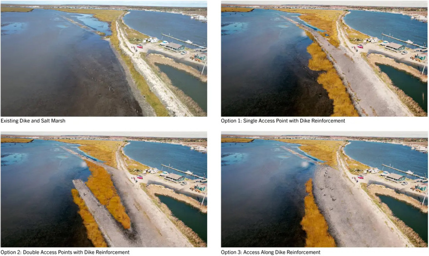
▲团队的建模研究为评估多种沉积物投放方案提供了关键依据,在提升生境质量、改善公共可达性及增强堤岸稳定性之间寻求平衡。Our team’s modeling was essential for exploring multiple sediment placement options to enhance habitat, recreation access, and dike stabilization. © EMLab

▲首轮沉积物投放完成后,将通过年度测绘与评估,为后续投放决策提供依据,以确保修复系统的长期稳定性。Initial placement will be surveyed and assessed annually to inform subsequent sediment placement needed to achieve sustained restoration viability. © EMLab

▲多年期植被调查对于确定适宜的高程基准(低位1.8英尺/高位3.2英尺)至关重要,以在短期内与后湾潮汐界面相匹配,从而提高植被恢复成功率。Multiyear vegetation surveys are crucial to set optimal datums (1.8’ low/3.2’ high) for revegetation relative to back-bay tidal horizons near-term. © EMLab

▲Abbotts Meadow区域目前通过管理措施来抑制芦苇的再生,而团队开展的植被调查是识别最易发生再侵占高程区间的关键手段。Abbotts Meadow is being managed to retard phragmites regrowth. Our vegetation surveys are key to assess elevations most susceptible to recolonization. © EMLab
PROJECT NARRATIVE
J.B. Jackson famously described landscape as “the art of time.” Change is implicit in this statement. Today, a significant challenge for landscape architects is designing for local, landscape-scale change within the broader context of global climate change. This task requires new mapping and modeling methods that integrate tools and knowledge from Earth system science—such as satellite data and sea level rise projections—with on-site surveying techniques. While surveying has historically been part of landscape practice, our discipline tends to outsource this work or rely on off-the-shelf data products, which are limited by the instruments and institutions that make them. This approach is inadequate for the challenges we face, particularly in rapidly changing coastal areas.
Our team is working with federal and state agencies to model and monitor six wetland restoration sites totaling 500 acres along coastal New Jersey. This work aims to create high-resolution models to determine sediment placement and track salt marsh elevation and vegetation composition over time. Such “nature-based features” are increasingly proposed to address weakened storm defenses, biodiversity loss, and carbon stock depletion resulting from wetland loss. These experimental yet critical features require understanding environmental dynamics across varied spatial and temporal scales. However, coastal wetlands are notoriously difficult to map using satellite-sensed data due to fluctuating water levels and variable spectral characteristics (the wavelengths of materials “seen” by sensors). This difficulty is compounded by the fact that state and federal land cover datasets overlook the complexity of these landscapes in favor of more generalized classifications. Moreover, due to limited access, conventional surveying equipment cannot be used in wetlands.
GPS-enabled drones, field survey receivers, and machine-learning algorithms enable novel methods to model and measure landscape changes. With these tools, we developed custom spectral libraries from field-collected data to create land cover maps at a “mesoscale.” The enhanced richness (resolution), reach (coverage), and return (frequency) of custom in situ data better capture the landscape characteristics needed for inputs into various models. These data and models are essential to determine material placement and profiles to support marsh viability. In addition, survey elevations taken from historical sediment placement sites were crucial for establishing target elevations to maximize the creation of high marsh habitats and optimize revegetation rates of low marsh areas. High marshes provide vital nesting sites and temporary refuge for key bird species during floods.
Our team will annually monitor each site to assess performance relative to modeled scenarios. The findings will serve as a blueprint for sediment placement techniques for landscape-scale restorations in other Atlantic Coast locations. Equipped with custom in situ remotely sensed data, designers can recover surveying as a central aspect of practice, contribute to new research frontiers, and participate in large-scale, interdisciplinary coastal infrastructure projects. J.B. Jackson understood that landscapes constantly evolve, but we no longer live in the temporal context he assumed. Landscape architecture is one of the few fields that offer ways to negotiate the misalignment between historical time, human experience, and the planetary time of global heating.


南京喵熊网络科技有限公司 苏ICP备18050492号-4知末 © 2018—2020 . All photos and trademark graphics are copyrighted by their owners.增值电信业务经营许可证(ICP)苏B2-20201444 苏公网安备 32011302321234号
苏公网安备 32011302321234号客服
消息
收藏
下载
最近