

创作上传
VIP
收藏下载
登录 | 注册有礼
查看完整案例

收藏

下载

分享
Rural Abundance & Vitality: The Chaobai River Basin | Sasaki
项目陈述
PROJECT STATEMENT
潮白河流域曾是一片充满活力的农业景观,但20世纪的河道硬化与整治打破了人水共生的关系,导致生态、文化与经济的多重割裂。本项目以乡村再生为目标,构建了一个融合生态修复、文化复兴与产业转型的综合框架。通过与28个村庄协同推进,规划修复滨水生态系统、重塑地方文化活动,并推动单一农业向多元生态农业转型。随着社区重新与河流文化建立联系,流域逐步形成一个生态健康、文化认同增强、产业可持续发展的韧性乡村景观,展现出乡村富饶与活力的更新模式。
The Chaobai River Basin, a historically vibrant agrarian landscape, faced ecological, cultural, and economic fragmentation after 20th-century channelization disrupted its human-river symbiosis. This rural regeneration initiative integrates ecological restoration, cultural reanimation, and economic revitalization into a cohesive framework. Collaborating with 28 partner villages, the plan restores riparian habitats, revives cultural traditions, and transitions monoculture farming to diverse agroecological systems. By reconnecting communities to their riverine heritage, the basin emerges as a resilient landscape where ecological health, cultural pride, and sustainable livelihoods thrive—exemplifying a model of rural abundance and vitality.

▲河道硬化与直线化改造对流域生态、经济与文化产生了深远影响,使区域逐渐陷入活力衰退与发展停滞。The channelization of the river causes ecological, economic, and cultural challenges to the basin, making it a place of stagnation and desolation. © Sasaki
项目说明
PROJECT NARRATIVE
数百年来,潮白河流域的28个村庄通过适应季节性洪水、水稻种植与水文化活动,与自然形成共生关系。然而,20世纪的河道工程以混凝土堤岸取代了自然岸线,使社区空间被割裂,生态与文化联系逐渐弱化。为重塑区域活力,项目提出了三大协同推进的再生策略。
第一,通过系统性的生态修复,将分散、刚性的水利基础设施转化为具有连续性的生态廊道,实现人与自然系统的协调共存。河岸被重构为多类型空间,从低干预的生态保护区到可参与的社区活动空间,提升生境多样性,并构建东亚—澳大利西亚候鸟迁飞通道的重要节点。同时,季节性滞洪区被整合为复合功能空间。约600公里低效灌溉渠被改造为生态走廊,通过人工湿地与本土植被系统净化农业径流、补给地下水。农业层面引入稻鱼共生、稻蟹共养等生态种养模式,逐步替代单一作物种植,改善土壤质量并提升产出稳定性。
第二项策略围绕滨水文化空间建设,打造具有活力的公共活动区,以当代设计方式重释地方传统,并推动农业与艺术融合的文化项目。互动展示再现了流域的造船历史;一年一度的“水收节”通过重现水上集市等传统仪式,将非物质文化与现代生活相结合;户外教学空间则传承传统农耕智慧,强化社区对本土文化的认同感与自豪感。
第三项策略构建区域经济转型框架,推动农业系统升级,并引导流域分区、差异化发展:上游发展康养与农业旅游;中游打造滨水公共客厅与农业公园;下游开展低碳农业示范项目。
项目突破单一作物模式,建立了多元生态农业体系,整合了低碳种植、农产品深加工与沉浸式生态旅游。具体内容包括:在2500公顷稻田实施稻蟹共养;2000公顷柿子园结合鱼塘功能,实现资源循环利用;建设1200公顷示范区,将莲藕种植与体验式旅游结合,形成可持续发展示范核心区。这些举措为青年创业提供了机会,也为新一代农民拓展了多元生计路径。
本项目的关键在于为期16个月的参与式规划过程。28个村庄围绕自身发展需求提出方案,同时与5个政府部门建立跨领域协作机制,确保政策衔接与资源统筹。该平台实现了大尺度、协同化的长期规划,在乡村振兴实践中具有示范意义。潮白河流域的更新表明,当生态修复、文化再生与经济创新形成协同机制时,河流将不再是空间边界,而是成为贯穿乡村发展的生命纽带,持续为区域注入活力与富饶。

▲在过去600多年的耕作与聚居历史中,当地形成了与水共生的生产与生活方式,而河道整治使人与河流的联系逐步减弱。Over 600 years of cultivation and development fostered a thriving culture that coexists with water until channelization pulled people from the river. © Sasaki

▲本项目将生态修复、文化复兴与经济振兴整合为统一的综合框架,推动流域的整体更新。The initiative integrates ecological restoration, cultural reanimation, and economic revitalization into a cohesive framework. © Sasaki

▲规划通过与28个村庄及5个政府部门的协作,构建了跨领域实施机制,系统推进了生态、文化与产业的协同转型。The plan engaged with 28 villages and 5 government agencies to implement cross-sector strategies for ecological, cultural, and economic renewal. © Sasaki

▲项目将破碎的河流水系与约7万英亩单一水稻种植区转型为连续、稳定且具有生物多样性的生态廊道体系。The plan transformed the fragmented river system and 70,000 acres of monoculture rice fields into a robust, resilient, biodiverse corridor. © Sasaki

▲河岸生态得到恢复,为包括东亚—澳大利西亚候鸟迁飞通道物种在内的野生动物提供栖息环境。Riverbanks are restored to create living areas for animals, including migratory birds traveling along the East Asian-Australasian Flyway. © Sasaki

▲滨水空间顺应季节性水位变化与动态气候条件,在提升防洪韧性的同时,营造多样化的公共活动体验。The shoreline leverages transformative seasonal water levels and a dynamic climate to balance resiliency and diverse public experiences. © Sasaki

▲单一农业与传统养殖塘被改造为稻鱼共生系统,将生态种养与湿地修复相结合。Monoculture farmlands and fishing ponds are transformed into a rice-fish symbiosis system that integrates organic fishing with wetland restoration. © Sasaki

▲总体框架以滨水生活为主题,通过文化线路与全年活动体系,重塑地方生活方式并激活非物质文化遗产。The framework celebrates riverside life and revives intangible heritage through thematic cultural routes and year-round programs. © Sasaki
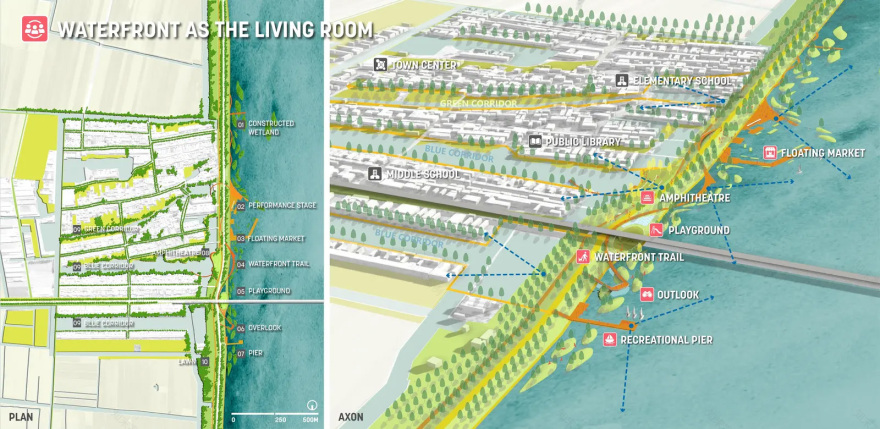
▲西河口滨水区整合公共空间、表演场地与水上集市,将传统仪式与现代休闲活动相融合。The Xihekou waterfront integrates public spaces, performance stages, and floating markets, blending ancient rituals with modern leisure activities. © Sasaki
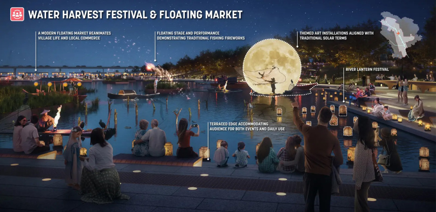
▲水上集市通过主题艺术装置、船上表演与季节性活动重现了传统水文化场景。The floating market reanimates ancient water-based traditions through themed art installations, boat performances, and seasonal events. © Sasaki

▲结合水稻农事周期开展教育项目与节庆活动,在强化社区参与的同时传承农耕文化。Education programs and festivals aligned with the rice harvest calendar will celebrate its cultural heritage with a sense of community. © Sasaki

▲区域协同发展推动生计多元化,包括农业旅游、农业主题公园与低碳农业,并由本地创业者参与实施。Coordinated development diversifies livelihoods like agro-tourism, agriculture parks, and low-carbon farming, initiated by local entrepreneurs. © Sasaki

▲试点区域通过整合莲藕种植、深加工与沉浸式生态旅游,打造气候适应型产业示范核心。This pilot area integrates lotus cultivation, processing, and immersive eco-tourism to establish a flagship hub for climate-resilient practices. © Sasaki
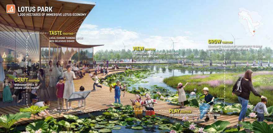
▲占地1200公顷的莲花公园形成兼顾经济效益与生态价值的发展模式,在促进区域可持续发展的同时增强地方认同感。The 1,200-hectare Lotus Park represents an economic model that drives sustainable development, and regional pride with economic opportunities. © Sasaki
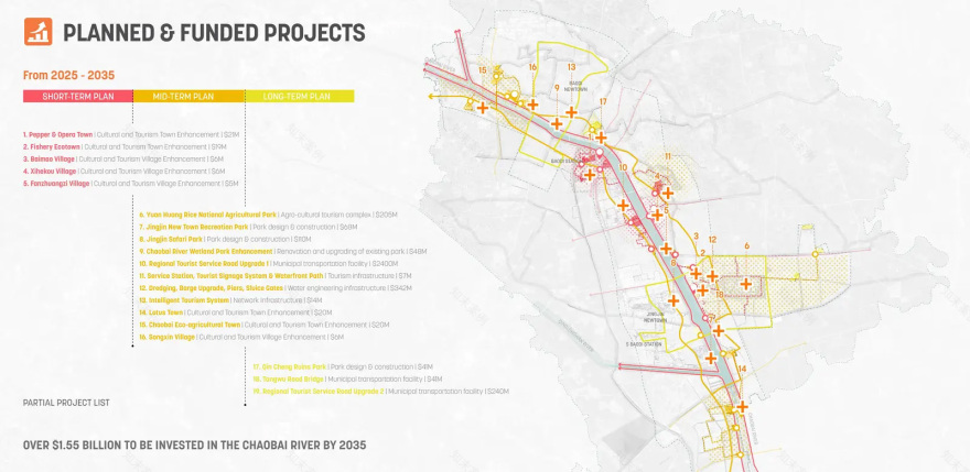
▲在政府与社会资本共同支持下,项目与相关利益方确定了18个试点工程,作为规划实施的首阶段启动内容。With sponsorship from both the public and private sectors, 18 pilot projects are identified with stakeholders to kick off the first stage of the plan. © Sasaki
PROJECT NARRATIVE
For centuries, the 28 villages of the Chaobai River Basin thrived through adaptive coexistence with seasonal flooding, rice cultivation, and water-based cultural practices. 20th-century channelization, however, imposed rigid concrete embankments that fragmented communities and eroded ecological-cultural connections. In response, an initiative to return the basin to an era of abundance and vitality launched a three-pronged regeneration process.
The first tenet includes a comprehensive ecological restoration strategy to transform fragmented infrastructure into resilient, biodiverse corridors that harmonize human and natural systems. Riverbanks are redesigned as adaptive typologies—from low-impact conservation zones to interactive community spaces. These interventions enhance habitat diversity, create migratory bird corridors along the East Asian-Australasian Flyway, and integrate seasonal floodplains as multifunctional spaces. 600km of underutilized irrigation canals are retrofitted into vibrant eco-corridors, blending constructed wetlands and native vegetation to filter agricultural runoff and replenish groundwater. Agroecological practices, including rice-fish symbiosis and crab co-cultivation replace monocultures, fostering soil health and sustainable yields.
The second tenet establishes a vibrant waterfront cultural district with public spaces that celebrate riverside life, reinterprets local heritage through contemporary design, and launches agricultural-art programs rooted in regional traditions. Interactive exhibits celebrate the basin’s shipbuilding legacy; an annual Water Harvest Festival reanimates ancient rituals like floating markets to blend intangible heritage with contemporary activities; and outdoor classrooms reinterpret ancestral farming wisdom while fostering pride in local identity.
The third tenet is an economic revitalization framework that guides upgrades to agricultural systems and promotes coordinated, differentiated development across the region. Upstream areas focus on wellness and agro-tourism; midstream areas include a waterfront living room and agriculture park; and downstream areas focus on low-carbon farming pilot projects. Breaking free from the constraints of single‑crop farming, the project champions a diversified agroecological model that integrates low‑carbon agriculture, value‑added processing, and immersive eco‑tourism. This includes 2,500 hectares of rice paddies integrated with crab co-cultivation; 2,000 hectares of persimmon orchards combined with fishponds to optimize resource cycles; and a 1,200-hectare demonstration area that merges lotus cultivation and immersive tourism to create a flagship hub for sustainable initiatives. These measures stimulate youth‐led enterprises and forge pathways to livelihood for the next generation of farmers.
Critical to this transformation was a 16-month participatory process. Over 28 villages actively contributed proposals aligned with their development priorities, while cross-sector partnerships with 5 key government agencies ensured policy alignment and resource coordination. This platform enabled large-scale, collaborative long-term planning—a rare achievement in rural revitalization efforts. The Chaobai River Basin’s renewal exemplifies how ecological stewardship, cultural reinterpretation, and economic innovation intertwine to create landscapes of abundance where the river is no longer a boundary but a thread weaving vitality into the fabric of rural life.
南京喵熊网络科技有限公司 苏ICP备18050492号-4知末 © 2018—2020 . All photos and trademark graphics are copyrighted by their owners.增值电信业务经营许可证(ICP)苏B2-20201444 苏公网安备 32011302321234号
苏公网安备 32011302321234号客服
消息
收藏
下载
最近