

创作上传
VIP
收藏下载
登录 | 注册有礼
查看完整案例

收藏

下载

分享
项目陈述
PROJECT STATEMENT
本研究探讨了在山地公园中整合地震预警与氡气监测系统的可行性,以提升整体防灾韧性。研究以龙泉山断裂带为对象,分析如何将地震风险评估与应对策略融入生态景观设计之中,实现防灾与环境建设的协同。
基于针对龙泉山公园的研究导向型设计,项目提出三项核心策略——山体地质修复(GRM)、氡气监测与分布测绘(RGM)以及地震监测与预警系统(EMA),展示绿色空间如何在保持生态与景观品质的同时,发挥灾害风险缓解功能。研究重点强调通过景观层面的干预措施,提升地震高风险地区的公共安全水平与可持续性。
This study explores the integration of earthquake early warning and radon monitoring systems within mountain parks to enhance disaster resilience. Focusing on the Longquan Mountain fault zone, it examines how seismic risk assessment and response strategies can be combined with ecological landscape design.
Through a research-driven design approach for Longquan Mountain Park, three key strategies—Mountain Geological Restoration(GRM), Radon Gas Mapping (RGM), and Earthquake Monitoring and Alert Systems (EMA)—demonstrate how green spaces can support disaster mitigation while maintaining ecological and aesthetic value. The study highlights landscape interventions to improve public safety and sustainability in seismic regions.

▲龙泉山断裂带累计发生过266次地震,面临滑坡及地质破坏等风险。本研究重点关注地震监测与灾害预防体系的建设。Longquan Mountain fault zone, hit by 266 quakes, faces landslides and damage. The study emphasizes earthquake monitoring and disaster preparedness. © ZAP Associates, Jun Zhou
项目说明
PROJECT NARRATIVE
1. 引言
龙泉山公园位于四川地震断裂带区域,长期面临地质灾害风险与生态退化问题。针对这一现状,本研究提出一体化景观策略,在提升防灾韧性的同时强化生态稳定性。项目联合成都市规划和自然资源局与万科集团开展,构建了一个融合地震灾害防控、生态修复与社区适应能力提升的综合框架。通过该策略,将原本脆弱的场地转化为可持续、具备韧性的山地公园,为地震高风险地区的创新型景观规划提供示范。
2. 三项地震减灾策略
基于面向龙泉山公园的研究导向型设计,项目提出三项核心策略,展示绿色空间如何在保持生态与景观品质的同时,发挥防灾减灾功能。
2.1 策略一:山体地质修复(GRM)
针对山体稳定性问题,项目通过系统性地质修复与生态加固措施,提升坡体安全性与整体生态功能。相关干预包括地表稳定处理、植被重建与水土保持优化等,能够降低滑坡与次生灾害风险,恢复山地生态系统结构与景观连续性,从源头增强场地的防灾能力与生态韧性。
2.2 策略二:氡气监测与分布测绘系统(RGM)
研究表明,在地震多发地区,地下氡气浓度变化是重要的地震前兆指标。项目在公园山地道路沿线布设地下氡气监测网络,对氡气波动进行持续观测。系统由15个数据采集装置组成,监测数据统一传输至山体监测中心进行分析处理,并生成颜色分级的风险分布图,用于快速识别地震发生时的高风险区域。该系统为龙泉山公园的灾害管理提供关键决策依据,同时其设施与景观环境融合设置,在提升监测能力的同时不影响生态与视觉环境。
2.3 策略三:地震监测与预警系统(EMA)
地震监测与预警系统(EMA)在公园范围内提供标准化、实时的预警信息,并与现有应急信息系统(如无线紧急警报等)联动。系统核心为一座抗震设计的监测塔,内部配置高精度地震仪,实现地震活动的实时监测,同时兼具地质观测与景观瞭望功能。数据处理中心对地震活动与地表位移进行持续分析,并将关键信息传输至预警中心,通过直观的地图化界面发布预警。该一体化体系显著提升应急响应效率,为灾前准备与灾时决策提供可靠支持。
3. 总结
本研究提出了一种基于景观系统的地震灾害缓解路径,通过整合山体地质修复(GRM)、氡气监测与分布测绘(RGM)以及地震监测与预警系统(EMA),实现灾害防控与生态修复的协同推进。该设计在强化地震监测与预警能力、提升区域防灾韧性的同时,也促进水土保持、滑坡防治与景观品质提升。除降低潜在经济损失外,该策略进一步将成都山地空间转化为集防灾、生态与公共活动于一体的复合型公共空间,增强区域生态韧性,并促进公众参与与社区认同。

▲研究团队联合成都市规划部门与万科集团开展合作,通过融合工程技术与生态理念,打造具备防灾韧性的山地公园。Researchers worked with Chengdu planners and Vanke to design a resilient mountain park, integrating engineering and ecology for earthquake mitigation. © ZAP Associates, Jun Zhou

▲作为示范场地,龙泉山公园位于地震高风险区域,通过将景观基础设施与地质条件及工程措施相结合,全面提升场地安全性与韧性。As mock-up site: Longquan Park, in a seismic zone, integrates landscape infrastructure with geology and engineering to enhance resilience. © ZAP Associates, Jun Zhou

▲项目围绕三项核心策略——山体地质修复、氡气监测与分布测绘以及地震监测与预警系统——构建完整而稳健的公园防灾基础体系。Three strategies—Geological restoration, Radon Gas Mapping, and Earthquake Monitoring built a robust park infrastructure. © ZAP Associates, Jun Zhou

▲在水文管理方面,通过设置缓冲带减缓地表径流并促进雨水下渗,同时利用排水沟渠减少侵蚀并将雨水引导至集中储存区域。The strategy employs buffers to slow runoff and improve infiltration, while drainage channels minimize erosion and direct rainwater to storage areas. © ZAP Associates, Jun Zhou
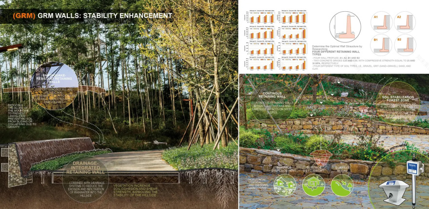
▲地质修复挡墙不仅用于控制水土流失,还可在地震中增强边坡稳定性,并集成滑坡预警监测功能。Building GRM walls serve as a mitigation measure to prevent erosion, enhance stability in earthquakes, and include monitoring for landslide warnings. © ZAP Associates, Jun Zhou
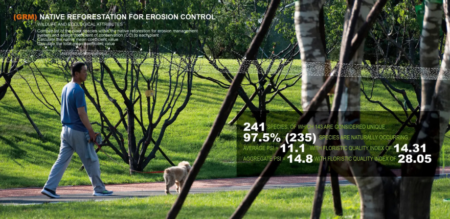
▲公园通过设置地质修复挡墙与乡土植被恢复,实现侵蚀控制与生态重建,形成以本地物种为主、生态结构稳定且多样化的山地生态系统。Park features GRM walls and native reforestation for erosion control, fostering a diverse, mostly native ecosystem with strong ecological integrity. © ZAP Associates, Jun Zhou

▲园区内布设的氡气监测管线可持续记录日常气体变化与地下活动情况,并通过景观化设计实现隐蔽设置,与环境自然融合。Radon monitoring pipelines track daily gas levels and underground activity throughout the park, seamlessly concealed within the landscape. © ZAP Associates, Jun Zhou

▲监测数据实时传输至监测中心,用于地震预测分析;RGM系统嵌入草坡景观之中,作为生态化设施示范应用。Radon data is sent to the Monitoring Center for earthquake prediction, with RGM system embedded in a landscaped grass slope as an ecological prototype. © ZAP Associates, Jun Zhou

▲RGM监测网络由156个传感器、15个数据采集装置及中央处理平台构成,为龙泉山公园提供持续的安全监测保障。RGM stations safeguard the mountain park, monitoring radon with 156 sensors, 15 collectors, and a central hub. © ZAP Associates, Jun Zhou
▲该系统将氡气监测与山地公园管理相结合,不仅提升监测能力,同时预留应急响应与灾害救援空间。This system connects radon detection with mountain park management, enhancing monitoring, providing space for emergency response and disaster relief. © ZAP Associates, Jun Zhou

▲EMA预警策略是现代应急体系的重要组成部分,通过统一标准的信息格式,在公园范围内实现清晰、同步的预警发布。EMA Strategy is a key part of modern emergency systems, providing a standardized format for clear, uniform alerts across the mountain. © ZAP Associates, Jun Zhou

▲监测塔集实时地震探测与数据分析功能于一体,在提升灾害应对能力的同时,也为区域风险评估提供全景观测条件。Merging real-time earthquake detection with analysis, the tower boosts disaster readiness while offering a panoramic view for hazard assessment. © ZAP Associates, Jun Zhou

▲地震观测平台同时作为景观观景点使用,将功能性与艺术化设计相结合,形成具有标志性的视觉体验。The earthquake observation platforms also serve as scenic viewpoints, combining function with artistic design for a striking visual experience. © ZAP Associates, Jun Zhou

▲EMA系统不仅支持地震监测、风险评估与应急响应,同时也作为山地公园可持续运行的重要基础设施组成部分。The EMA system supports earthquake monitoring, hazard assessment, and emergency response while serving as a sustainable mountain park. © ZAP Associates, Jun Zhou

▲整体研究通过整合山体修复(GRM)、氡气监测与分布测绘(RGM)及地震监测与预警系统(EMA),实现灾害防控与生态修复的协同发展。This research design combines Mountain Restoration (GRM), Radon Gas Mapping (RGM), and EMA for hazard prevention and ecological restoration. © ZAP Associates, Jun Zhou
PROJECT NARRATIVE
1. INTRODUCTION:
Located in a seismic fault zone in Sichuan, Longquan Mountain Park faces ongoing geological risks and ecological degradation. In response, this study explores an integrated landscape strategy that enhances both disaster resilience and ecological stability. Collaborating with the Chengdu Municipal Bureau of Planning and Natural Resources and Vanke Group, the research team developed a framework that combines seismic hazard mitigation, ecological restoration, and community adaptability. This project transforms a vulnerable site into a sustainable, resilient park, setting a model for innovative landscape planning in earthquake-prone regions.
2. THREE EARTHQUAKE DISASTER MITIGATION STRATEGIES
Through a research-driven design approach for Longquan Mountain Park, three key strategies demonstrate how green spaces can support disaster mitigation while maintaining ecological and aesthetic value.
2.1 Strategy 1. Geological Restoration of the Mountain (GRM)
Research reveals that radon fluctuations in seismic-prone regions are key to earthquake monitoring. Integrated along park roads, the Underground Radon Gas Measurement (RGM) system continuously tracks radon fluctuations—key seismic indicators. Data from 15 collectors is processed at a mountain monitoring center, generating real-time, color-coded risk maps for rapid earthquake assessment. Designed to blend into the landscape, this system enhances disaster preparedness while maintaining ecological balance.
2.2 Strategy 2. Radon Gas Measurement Map Systems (RGM)
Research reveals that radon fluctuations in seismic-prone regions are key to earthquake monitoring. The radon system along Park’s mountain roads provides critical data, helping disaster management in Longquan Mountain swiftly identify high-risk areas during seismic events. A network of Radon Gas Measurement (RGM) units continuously tracks radon fluctuations. Data from 15 collectors is processed at a mountain-based monitoring center, generating color-coded risk maps for rapid
2.3 Strategy 3. Earthquake Monitoring Alert System (EMA)
The Earthquake Monitoring Alert System (EMA) provides standardized, real-time alerts across the mountain, integrating with emergency warning systems like AMBER alerts and Wireless Emergency Alerts (WEA). At its core, an earthquake-resistant Monitoring Tower houses advanced seismographs for real-time detection while doubling as a scenic observation point for geological assessments. Data Processing Centers track seismic activity and soil displacement, relaying critical insights to the Alert Center, which delivers intuitive, map-based warnings. This integrated system enhances emergency response efficiency, ensuring swift, informed decision-making for disaster preparedness.
3. CONCLUSION
This study presents a landscape-based approach to earthquake disaster mitigation by integrating Geological Restoration of the Mountain (GRM), Radon Gas Measurement Mapping(RGM), and the Earthquake Monitoring Alert System (EMA). By combining advanced hazard prevention with ecological restoration, the design enhances seismic monitoring, early warning, and disaster resilience while also promoting soil and water conservation, landslide mitigation, and landscape aesthetics. Beyond reducing economic losses, this strategy transforms Chengdu’s mountainous terrain into a multifunctional public space, fostering ecological resilience and community engagement.
南京喵熊网络科技有限公司 苏ICP备18050492号-4知末 © 2018—2020 . All photos and trademark graphics are copyrighted by their owners.增值电信业务经营许可证(ICP)苏B2-20201444 苏公网安备 32011302321234号
苏公网安备 32011302321234号客服
消息
收藏
下载
最近