

创作上传
VIP
收藏下载
登录 | 注册有礼
查看完整案例


收藏

下载

分享
你可能还喜欢
换一换

"一个非常令人信服的全方面的和坚实的分析形成了综合的总体计划"——2018年IFLA评审委员会
"A very convincing synthesis and solid analysis has led to an integrated master plan."
——2018 Awards Jury
项目概要Project statement
基地位于安徽省会合肥市,巢湖北侧,中国五大淡水湖之一。滨湖的建设使生态逐渐被瓦解,农药的使用也加剧了水质的污染,村镇扩张也受到洪水的威胁。我们接到的任务是在巢湖北岸,规划一处大型的湿地公园,用于调节生物多样性、水资源等生态保护和农民传统农业转型发展之间的矛盾。
The site is located in Hefei City, Anhui Province, adjacent to the northern shore of Chaohu Lake, which is one of the five largest freshwater lakes in China. Endangered by lake-around construction and deteriorated by water contamination caused by overusing agricultural chemicals, Chaohu ecological system undergoes gradual collapse. Meanwhile, rainfall floods make a danger for newly-expanded towns and villages. The mission for us is to plan a major wetland park at the north shore in the hope of handling the contradiction between ecological protection and the transformation and development of traditional agriculture.
▼湿地公园总平面,site plan

水质污染|Water pollution
生活污水、农业用水的排放,湿地被侵蚀、净化功能减退,导致巢湖水质不断下降,蓝藻等问题十分严峻。
With domestic and agricultural sewage discharged, the area of wetlands shrink and the function of purification weakens in Chaohu Lake. Consequently, serious environmental problems arise, such as declining water quality and rampant cyanobacteria.
▼水质污染,water pollution

洪水威胁|Rainfall flood threat
由于城镇化不断发展,大面积的开垦、围湖造田导致大量湿地消失,汇水能力减弱,村镇受到洪水威胁。
Due to the increasing development of urbanization and uncontrolled land reclamation, a large size of wetland disappears. Correspondingly, the water catchment capacity drops. Villages and towns are under the threat of floods.
洪水威胁,flood treat

目标Objectives
1.完整的生态网络:织补碎片化的生态斑块,构建具有弹性的,水网绿网。
2.健康:恢复湿地净化功能。
3.安全:扩融雨洪承载力。
4.宜居:依水而居的美丽村落。
5.难忘:科普功能、地方特色的“湿地小镇”。
▼概念,concept

现状水系识别:通过GIS,识别出现有水塘、鱼塘、藕塘、水渠、人工水库等位置。潜在径流:通过地形、坡向,找到汇入巢湖的15个汇水区,并分析出潜在的雨水径流位置。
To identify puddles, fish ponds, lotus root ponds, canals and man-made reservoirs through GIS. Covert runoffs: to locate 15 water catchment areas into Chaohu Lake and covert runoffs according to terrain and slope direction.
水网识别,water network identification

雨水滞洪|Flood detention
按10年一遇标准,采集分析15个汇水区,一年12个月每月的降雨量。
计算出每个区域需要的滞洪区面积。从而根据雨水承载力,确定出每个区需要的湿地面积。
With reference to floods in the latest ten years, the rainfall of 15 catchment areas is to be collected and analyzed.
a) to calculate the area of flood detention basin in need
b) to calculate the area of wetlands in need with reference to their rain water capacity
▼洪水管理,flood detention

水系统规划|water system connected and purification
疏浚现有阻塞沟渠,构建水塘——沟渠湿地——末端湿地的三级水网,并最终排入巢湖。在中水厂出水口设置净化湿地,将巢湖水质作为目标水质,(近期四类、远期三类水质),计算得出需要新增净化湿地面积近期:51667 m2 ,161667m2,(按平均水深1.5M计算)。
a) to dredge blocked ditches
b) to build new ditch wetlands according to the location of potential runoffs
c) to weave the pool-ditch wetland-terminal wetland tertiary water network.
d) to improve Chaohu water quality, targeting at the forth-class water quality in the short term and the third-class water quality in the long term
e) to calculate the area of wetlands in expectation, respectively 51,667m² in the short term and 16,1667 m² in the long term(mean depth 1.5m)▼水系统规划,water system connected and purification

生态廊道建立|Ecological corridor building
选择巢湖湿地具有代表性的指标物种——白鹭,通过GIS完成生境斑块的识别。参考历史时期土地利用情况,应用最小成本路径法模拟迁徙网络。建立现状、恢复、新建耦合条件下的斑块、节点、廊道的综合生境网络。我们识别出现状最好的生态栖息地,并扩大了保护范围。我们识别出潜在的栖息地,并根据动物的习性和当地植物群落,确定了恢复的范围和树种。
By observing egretta garzetta, the local indicator species, we identify Habitat patches via GIS.
Planning strategies
a) we simulate the migration network by the method of minimum cost path.
b) we establish a comprehensive habitat network composed of patches, nodes and corridors with reference to an integration of current situation, recovery and prospects.
c) We identify currently-top ecological habitats and promote the expansion of reserves.
d) We identify prospective habitats and make recovery plans of fields and trees according to specific animals and plants.
▼绿网·白鹭迁徙廊道建立,ecological corridor building

▼绿网·生境恢复,biotope recovery

产业提升|Industry development
分析现状土地利用的位置、面积,统计有污染的农业方式的种类。淘汰使用农药的产业,建立水生蔬菜种植、生态种养、旅游服务等新型生态产业。
We survey the location and area of land in use, with a particular focus on pollution-causing farming ways. To replace pesticide-involved industries with aquatic vegetable cultivation, ecological planting, tourism services and other new ecological industries.
▼产业提升,industry development

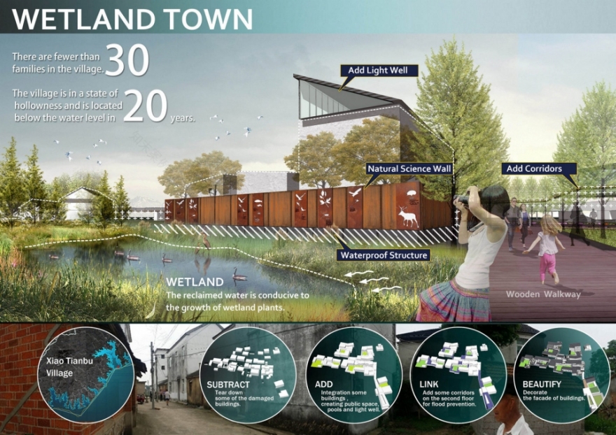
湿地小镇|Wetland town
采集周边27个村庄的面积、户数、规模、位置。根据村庄与湿地的关系,位于生境敏感区的村庄进行搬迁;位于出入口的村庄进行改造提升,为游客服务;具有特色的村庄改造为“湿地小镇”。
To collect the area, number, size and location of 27 surrounding villages.
Planning strategy
a) Considering the interaction between villagers and wetlands, we plan to remove villages located in habitat sensitive areas.
b) The villages located at the entrance and exit are upgraded to serve tourists.
c) With its folk houses transformed into popular science exhibition rooms and a wetland museum and other service facilities supporting, Xiaotianbu Village, together with other disappearing ones, will gradually develop into “a wetland town”.
▼湿地小镇,wetland town
影响力
Prospects
1.恢复湿地面积262公顷
2.可承载20年一遇的洪水。
3.巢湖远期水质达到3类水质。
4.新增了9处大于10公顷的生态核心斑块,恢复了栖息地3处。
5.将硬质河道生态化改造了7.02公里。
6.升级原有污染农业产业128公顷。
7.产业升级后,农民收入每亩3000元有望提升到5000元
8.公园改善了游憩设施。
1.Recovery of 262 hectares of wetlands.
2.Capacity to bear rainfall flood in the coming 20 years.
3.The third-class water quality in the long term.
4.10-hectare expansion of core ecological patches and recovery of 9 habitats.
5.7.02-kilometer ecological rebuilding of river course.
6.128-hectare replacement of polluting agricultural industries.
7.Income increase from 3,000 to 5,000 yuan per acre.
8.Significant improvement of refreshment facilities.
▼主要湿地区平面,main wetland site plan

设计时间:2017年5月至2018年2月
主创景观师:杨扬
景观规划设计团队:石磊、刘硕、赵艳、王卉
湿地调查研究:杨永峰
生态数据分析:李加忠
种植设计师:贾以欢
项目地址:安徽省巢湖市
项目占地面积:998.36公顷
摄影师:杨扬
合作方:国家林业局调查规划设计院
客户:巢湖市政府
南京喵熊网络科技有限公司 苏ICP备18050492号-4知末 © 2018—2020 . All photos and trademark graphics are copyrighted by their owners.增值电信业务经营许可证(ICP)苏B2-20201444 苏公网安备 32011302321234号
苏公网安备 32011302321234号客服
消息
收藏
下载
最近